Wonderful Road Views: Gonzaga To Tuguegarao
This is still part of my travel from Sta. Ana to Tuguegarao. And, from the last article, I said I only started enjoying the views once I was out of the economic zone, right? I was already in the next town... Gonzaga.
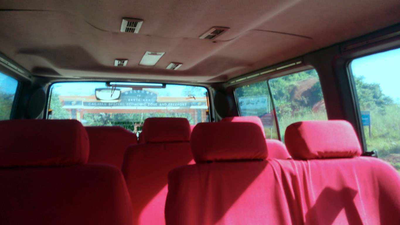
Here, I took this pic not to capture the insides of the vehicle I was riding on... I took that to capture a shot of that welcome arch to the "Cagayan Special Economic Zone and Freeport" (yun ang nakasualt dun!) - already behind me! That is for me to remember its name, and to remember that the things I saw henceforth were lovely hehe.
So goodbye ecozone, a.k.a bagsakan ng basurang sasakyan at tambayan ng mga sugarol na insik! Not that the place is ugly. Sta. Ana, by its natural surroundings is a gem of a paradise in itself. No need to erect gambling havens - and lalo namang not inside a naval base!
I was now cruising the national highway in the town of Gonzaga...
Hey I noticed many of the bigger bridges here-arounds look interesting like this!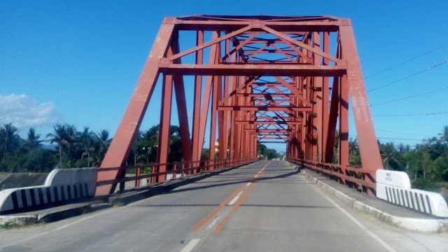 Maybe its a 'DPWH signature' bridge style? Yep, I know the color is DPWH, but most of their newer constructions here (along this highway anyway) look like that - I like them. Wala lang. I just want to say, I like how they look!
And I said.. "what is that?"... I specifically asked the driver to go a little bit slow while overtaking that thing!
A rice mill? Or a thresher? On four wheels! Whatever, basta I was fascinated to have seen this thing. I think I have seen similar "gadgets" (hehe gadget ba tawag dyan?) in Vietnam and/or Thailand. But first time I saw such a thing in our inang bayan. Interesting!
Whatever it does, I wish there'd be something like that all over the country. Yeah, sana all! Then again, the thing might be expensive to have at smaller islands - unlike here in Cagayan Valley where rice fields are as far as the eyes can see. So that, purchasing and using them here is worth it - I mean worth the expense.
See?! Fantastic sights!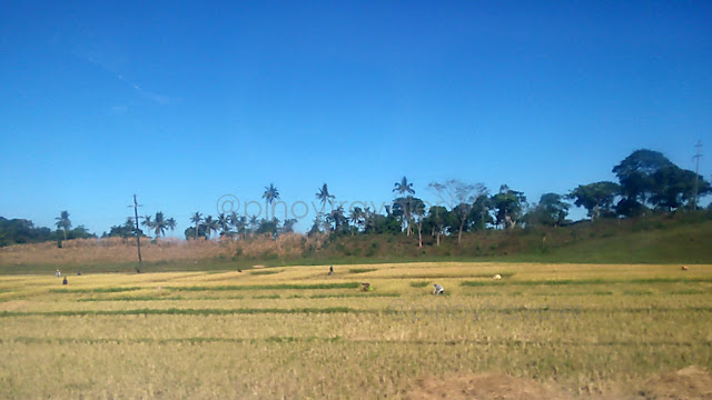 Ricefields in golden 'harvest season' colors.
Cornfields now colored brown... Due to the leaves and stems already dry and wilted after harvest. Gandang tanawin...
How about this... almost like a work of art, right?! NO not the tricycle hehe! The golden grain laid out on both sides of the highway! While this "method" is common all over the country, what makes this different is the length - meaning they have more of the grain to be sun dried. It stretches for kilometres and kilometres on end!
Those sacks are about to be emptied unto the pavement... Yep, more palay to be dried. This must take a lot of manpower - manually offloading the sacks from trucks, emptying them out, and raking the grains to spread on the pavement. Now imagine if it suddenly starts to rain. Awk! What a chore!
Those grains, yes, palay, came from fields like this... So many wide fields, as I said "as far as the eyes can see" planted to rice, rice, corn, and more rice! Now I am imagining... how would these fields look like when the rice stalks are just about starting to grow? Hmm, stretches and stretches of green... yes in various shades of green..! Wow, must be instagrammable!
Then I arrived at Gonzaga town proper (poblacion)... That is their municipal building. Nice looking. And if I can judge from how the center of town looks, Gonzaga is definitely more progressive than Sta. Ana. Even if it does not have a junk car expo or casinos for the Chinese.
Hey I saw interesting signs/names and asked my driver about them. So I learned, that Gonzaga has unique barangay names at center of town. Examples are: Progressive, Smart, Flourishing, Paradise! Whoa! Kakaiba 'no?! Di katulad nyo, lahat nalang yata ng bayan sa bansang ito eh meron Barangay San Jose! Oops, Gonzaga does have a barangay named San Jose hahaha!
Moving southwards beyond Gonzaga proper, here is that kind of bridge again... Pateng! Yes it's named Pateng Bridge. Uhmm I don't know what it means in Ilocano or Ybanag. Kay sa amon sa Ilonggo country ba la, that means "kalapati" or "pigeon". My driver told me that Pateng is the name of the barangay where this bridge is. Okay let's rest our case hehe!
The interesting part that I wasn't able to capture on camera was: there were a lot of people swimming under the bridge! Not just kids or teenagers. Entire families having picnics. There were even cottages and tents down there! Ang saya!
This only means the rivers in Gonzaga, Cagayan are still fresh - because people won't dare swim if the water is like Pasig River, right?! Let's hope they'd be able to keep it that way for many many years more. Now, that river is an example of what I call "ah the wonderful life in the province"!
Eto na, as if on queue to end my "panandaliang aliw" as we exited Gonzaga... driver told me "pero pag tag-ulan o kaya me bagyo sir, lahat yan lubog sa baha"! Argh! In my mind (though I almost said this) I was like screaming "walang basagan ng trip"! Hahaha!
So there... we were out of Gonzaga.., Still moving southwards on this well-paved highway to Tuguegarao.
But the golden grain views continue...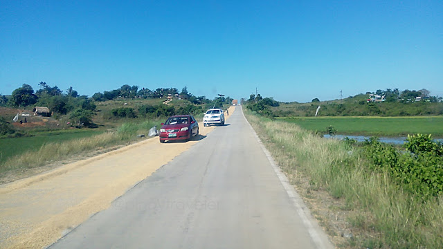 Note that the road here is narrower (shoulders are not paved). But just the same, they spread out their harvest for sun drying - on half the width of the highway!
Sometimes its on the left, sometimes on the right. Their choice :) Note my camera position. We were traversing the road on the left side instead of the right. Driver told me, it is okay to run over those grains - owners can not and may not complain. But motorists do avoid them where possible. I asked the driver why, and his reply was "grasya sa dios yan sir". Uh huh, my lips are sealed now hehe!
See here... ganda di ba? Fantastic view of that solitary tree hehe! And we were still very far from Tuguegarao. I guess these last three pictures would have been either in the town of Sta Teresita or in the town of Lal-lo.
Lal-lo, ah, did I just say the town of Lal-lo?!
There was another new thing I saw there.
But let that be a separate story or actually the next one :)
So after Lal-lo, we proceeded on, and the next notable sight I saw was this... This is a very crucial intersection says my driver. He says, there are many travelers driving on their own who get lost, more on go astray, instead of following the correct road to their destination! The signs are few and too small, so not easily seen by drivers.
Okay, here is a closer shot of that intersection called Magapit Junction... Yes, this is in Brgy. Magapit, Lal-lo, Cagayan. Now listen to this: if you turn right, that road will take you to Aparri (about 30kms) and nowhere else, unless you turn right to Buguey, then Sta Teresita then back to Lal-lo, meaning here, this intersection hahaha!
If you go straight ahead and cross that bridge (called Magapit Suspension Bridge), you will have crossed the biggest and longest river in the country, the Rio Grande De Cagayan or Cagayan River, and on to the northwestern towns of Cagayan like Allacapan, Ballesteros, etc., or the province of Apayao, or even Ilocos Norte na! And...
Turning left, though it doesn't look like the main highway, is the way to Tuguegarao!
And then I saw a castle! I jokingly asked the driver "adnyan ba si Rapunzel? or the beast?"... And the driver said "ah, castle sir, Castle In The Sky". I did not respond, I just smiled. But he went on telling me that the back side of this thing has a good view of the suspension bridge and the river.
Pasensya sa pictures, I took all these while the van was at full speed!
Beside the castle is this... Cagayan Breeze Food Harbor... But I nor the driver were not hungry yet. It was only about 930AM. He did tell me that most of the folks who visit the castle and the suspension bridge (style Golden Gate daw), usually eat at this place.
Not long after we were in the town of Gattaran, and I saw this...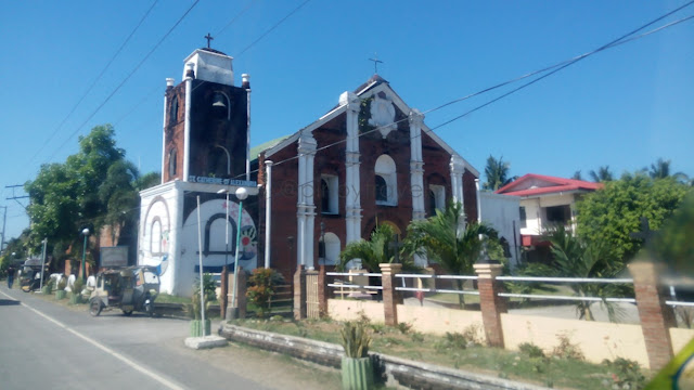 St. Catherine of Alexandria Church. Nice looking especially in the morning sun!
In this area going southwards, bridge are of a different style... Maganda pa rin, if I may say so. I like those steel braces whatever it is called :)
Oh hey, they also have that here! The tricycle with four wheels! And functions like a jeep in terms of load and route! I remember they call this thing "Center Car" in Calbayog.
And OMG they're also going home now! The pack of big-bikers! Inggit ako! These are the guys who arrived at Anguib beach in those bikes, while I was already there doing nothing (nag-muni-muni ba)! Some of them stayed at Country Inn By The Sea.
There's a forest along the Cagayan Highway? Its not all rice fields after all..! I am not even sure at which town was this - but I was traveling between Gattaran and Alcala. So that's any one of them or between them :)
We passed here as I was busy tinkering with google. I was about to request the driver... Argh! He was too fast. I didn't even get to see the name of that big church. Was this in the town of Alcala? Probably so. Because next thing I know, driver was already parking his vehicle so I could visit my "inaanak" at center of town. Yes, I did!
Then there were the fields again... This is an after-harvest stage of the plantation. No, I am not sure if that front area has just been burned. Hindi naman yata. Mukhang dark lang ang soil.
And another river where folks bathe, swim, even wash their laundry... I would very much love to live in such a place - basta me wifi ha?! :D
Next town... getting near to Tuguegarao...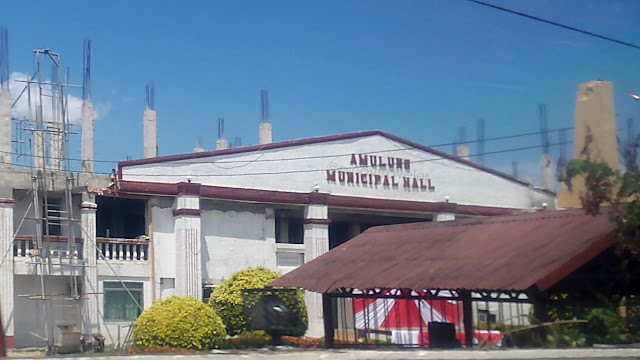 I was a bit curious about this little town, but driver said there was nothing to see there. Ows?!
Whoa! For a change, I saw green, instead of the usual golds and browns of summer! Modern times, advanced methods and technologies, you may now plant rice anytime!
Iguig. Yep, after that welcome arch, we turned right going up to the calvary hills But let's do that as a separate story. In my next entry. Promise!
Meantime, let us end the road views of my travel from Sta. Ana going Tuguegarao! Next entry will be my visit to Iguig Calvary Hills and after that, Tuguegarao again, yey!
==========================================
Click these numbers for a chronology of my notes:
01
02
03
04
05
06
07
08
09
10
11 12 13 14 15 16 17 18 19 20
21 22 23 24 25 26 27 28 29 30
31 32 33 34 35 36 37 38 39 40
41 42 43 44 Forty four stories just 4U!
==========================================
Or just click "Newer Post" or "Older Post" below.
Here, I took this pic not to capture the insides of the vehicle I was riding on...
So goodbye ecozone, a.k.a bagsakan ng basurang sasakyan at tambayan ng mga sugarol na insik! Not that the place is ugly. Sta. Ana, by its natural surroundings is a gem of a paradise in itself. No need to erect gambling havens - and lalo namang not inside a naval base!
I was now cruising the national highway in the town of Gonzaga...
Hey I noticed many of the bigger bridges here-arounds look interesting like this!

And I said.. "what is that?"...

A rice mill? Or a thresher? On four wheels!

Whatever it does, I wish there'd be something like that all over the country. Yeah, sana all! Then again, the thing might be expensive to have at smaller islands - unlike here in Cagayan Valley where rice fields are as far as the eyes can see. So that, purchasing and using them here is worth it - I mean worth the expense.
See?! Fantastic sights!

Cornfields now colored brown...

How about this... almost like a work of art, right?!

Those sacks are about to be emptied unto the pavement...

Those grains, yes, palay, came from fields like this...

Then I arrived at Gonzaga town proper (poblacion)...

Hey I saw interesting signs/names and asked my driver about them. So I learned, that Gonzaga has unique barangay names at center of town. Examples are: Progressive, Smart, Flourishing, Paradise! Whoa! Kakaiba 'no?! Di katulad nyo, lahat nalang yata ng bayan sa bansang ito eh meron Barangay San Jose! Oops, Gonzaga does have a barangay named San Jose hahaha!
Moving southwards beyond Gonzaga proper, here is that kind of bridge again...

The interesting part that I wasn't able to capture on camera was: there were a lot of people swimming under the bridge! Not just kids or teenagers. Entire families having picnics. There were even cottages and tents down there! Ang saya!
This only means the rivers in Gonzaga, Cagayan are still fresh - because people won't dare swim if the water is like Pasig River, right?! Let's hope they'd be able to keep it that way for many many years more. Now, that river is an example of what I call "ah the wonderful life in the province"!
Eto na, as if on queue to end my "panandaliang aliw" as we exited Gonzaga... driver told me "pero pag tag-ulan o kaya me bagyo sir, lahat yan lubog sa baha"! Argh! In my mind (though I almost said this) I was like screaming "walang basagan ng trip"! Hahaha!
So there... we were out of Gonzaga..,

But the golden grain views continue...

Sometimes its on the left, sometimes on the right. Their choice :)

See here... ganda di ba? Fantastic view of that solitary tree hehe!

Lal-lo, ah, did I just say the town of Lal-lo?!
There was another new thing I saw there.
But let that be a separate story or actually the next one :)
So after Lal-lo, we proceeded on, and the next notable sight I saw was this...

Okay, here is a closer shot of that intersection called Magapit Junction...

If you go straight ahead and cross that bridge (called Magapit Suspension Bridge), you will have crossed the biggest and longest river in the country, the Rio Grande De Cagayan or Cagayan River, and on to the northwestern towns of Cagayan like Allacapan, Ballesteros, etc., or the province of Apayao, or even Ilocos Norte na! And...
Turning left, though it doesn't look like the main highway, is the way to Tuguegarao!
And then I saw a castle! I jokingly asked the driver "adnyan ba si Rapunzel? or the beast?"...

Pasensya sa pictures, I took all these while the van was at full speed!
Beside the castle is this... Cagayan Breeze Food Harbor...

Not long after we were in the town of Gattaran, and I saw this...

In this area going southwards, bridge are of a different style...

Oh hey, they also have that here! The tricycle with four wheels!

And OMG they're also going home now! The pack of big-bikers! Inggit ako!

There's a forest along the Cagayan Highway? Its not all rice fields after all..!

We passed here as I was busy tinkering with google. I was about to request the driver...

Then there were the fields again...

And another river where folks bathe, swim, even wash their laundry...

Next town... getting near to Tuguegarao...

Whoa! For a change, I saw green, instead of the usual golds and browns of summer!

Iguig. Yep, after that welcome arch, we turned right going up to the calvary hills

Meantime, let us end the road views of my travel from Sta. Ana going Tuguegarao! Next entry will be my visit to Iguig Calvary Hills and after that, Tuguegarao again, yey!
11 12 13 14 15 16 17 18 19 20
21 22 23 24 25 26 27 28 29 30
31 32 33 34 35 36 37 38 39 40
41 42 43 44 Forty four stories just 4U!


Comments
Post a Comment