Road Trip: MacArthur Javier Abuyog Silago
My title sounds like a long name of a person or place. But, those are names of 4 towns! This is still part of my "Eastern and Southern Leyte Joy Ride" that started in Tacloban.
Taking off from my last stop, here goes my notes traversing the 'east' side of the island, from MacArthur (Leyte) to Silago (Southern Leyte). Probably about 60kms. of good roads.
Let me start with this Balocawe Bridge at the southern exit of MacArthur... It does not show on this photo, but the weird thing is: this highway has four lanes after you cross this bridge. Will DPWH widen the bridge and this side of the road too? Sana!
Look! At 7kms to Abuyog, the road is fantastic! (yung tinatawag kong 4 lanes hehe) The sides (I think they're called "shoulders") are newly paved - O, di ba 4 lanes! And the main lanes are asphalt over concrete. You'll be tempted to "fly" - if you were driving! As for me, when I say "lipad Jonathan lipad", the prompt reply is "sir, protocol, 60 to 80 kph"!
Anyway... from that bridge on, this is part of the town of Javier (pronounced "ha-vyer").
This is the famous (or infamous) intersection because many motorists get 'lost' here! I know some of them who did not turn here hehe, heheeee! The national highway curves leftwards to Abuyog and elsewhere, while going straight (that road on the right) goes for 6.6kms to town center of Javier and nowhere else. So, you drive back for 6.6kms hehe!
That's probably the reason why they peppered this corner with more signage (others not seen in the picture). At a hundred or fifty meters before this intersection, it really looks like the national highway just goes straight (to the town center of Javier or poblacion)!
At kung maka-signage naman si DPWH... pati decimal numbers are included talaga! Eh, the decimal positions are not uniform as to tenths, hundredths or thousandths. Some might think those are commas instead of periods! Confusing but comedy relief anyway!
The best landmark to watch out for at this corner is: there's an Andok's branch at left. Yes, there it is, on a side of the road, in the middle of nowhere haha! Wheh, bakit, there's an Andok's branch at the surf camp area in Guiuan, also in the middle of nowhere di ba?!
Aha, speaking of Andok's... I did not know (until I got this assignment in Region VIII last year) that Andok's is owned by the Javiers of Javier. Did you know that?! I really did not!
Yes, political clan, though the most famous of them - Danny Javier of Apo Hiking Society - is not (yet). He is brother to incumbent Mayor Leonardo “Sandy” Javier Jr., the one who started Andok's at West Ave., QC in 1985. The town is named after the surname of their grandfather - Daniel Falcon Javier, who historically started "civilization" in this place! He was a retired Principal of Cebu Normal School, and hailed from Sogod Southern Leyte.
Anyway, I'll be going to center of this town soon, so let's just make a flyby for now.
Entering the town of Abuyog... this is actually still a bit far from Abuyog town center.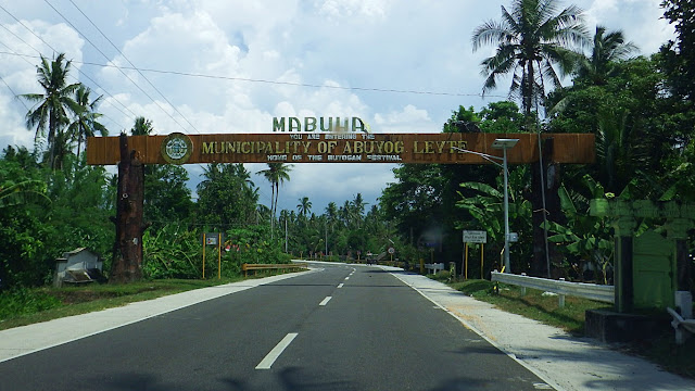 This is the Javier-Abuyog boundary, about 400 meters from that corner described above.
And here is another tricky road fork intersection - actually a reverse of that one above! On this intersection, many who are going to Abuyog's poblacion (left road) mistakenly end up going straight ahead - to places like Mahaplag, Baybay or Southern Leyte haha! Clear and BIG highway signage needed here Mr. DPWH, please! Yung parang sa EDSA!
Still in Abuyog, I like looking at their fields of green (or gold during harvest)!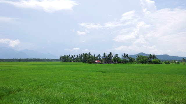 Oh, did you know? Abuyog has the biggest land area among the towns or cities on all of Leyte Island! In fact, Javier, Mahaplag, MacArthur were once just barangays of this town.
And yes, this is where the famous Buyogan Festival is held.
Approaching the junction where travelers turn left to Silago... [bigger signage please?] Without saying anything, driver stopped the car near one of the little stores in this area. When already out of the vehicle, he asked if I wanted to do a "BRB" ("bathroom break" yan, sanay si kumag sa yahoo chat of yesteryears)! So I did. And puffed a cigarette too!
I noticed he checked the car in-and-out, including our usual snacks, water and Coke!
And we went for it... here I go Silago! [Oh, Mr. DPWH, signage please nga! Make it BIG!] First time for me turning left here and onwards to Silago. I am used to going straight ahead - to Mahaplag or onwards to Baybay; to Agas-agas; even shortcut to Sogod, etc.
When we were moving again, I asked my driver why the unannounced and unscheduled meticulous "preparations" at the junction store. After some hesitation, he replied... that from here on, all the way to Silago, there are only fields and mountains with practically no people nor houses, much less stores, gas stations or vulcanizing shops along the way.
I said okay (but not convinced), so here we were starting off on the Abuyog-Silago Road I continued asking questions, because, the meticulous checks were deliberate, serious and uncommon. He even checked if my personal phone AND the satellite phone were fully charged. Eh, we were not off to an island naman nor veering off the national road! But I was getting the same reply - kesyo desolate highway, nothing until Silago. Hmm...
Anyway..,
Just about 3kms from that junction (this is still Abuyog), I saw this distressing sight... Far from the road, but I could somehow discern, something is not well about that school - some (or all?) buildings seem to have just been left in ruins. Particularly that, encircled.
I asked the driver to stop the car so I could attempt a zoom on my phone. And I think my samsung gave me a good enough zoom. Well, to my dismay, what a sorry state this building is in. All I could do was whisper "wala bang tumutulong sa kanila"?
Nice road views, even if the skies started to get dark with a... thunderstorm, maybe? The kilometer marker says we were 41kms away from Silago. Hmm, less than an hour?
So I said to my self "malapit lang naman pala". The driver heard me and said "yes sir pero maraming bundok". And I think this was off-topic, but driver requested "sir, pwede last stop na natin yun hanggang makarating ng Silago"? He sounded serious and pleading!
Now that got me back to the previous topic - why the notably careful preparations. And I (re)started by asking: "so what's the problem, maganda ang kalsada, wala pang traffic o!"
Eto na... it all came out finally! His story is... sometime ago, when he was still driving a delivery truck for a universal food corporation, this route was not yet paved. Of course all the more that there were no people nor houses along the way, AND this whole stretch (especially up the mountains) was a notorious hold-up/robbery area. Oh my gino-o ko!
His 'tactic' that time was: 'never travel this way late afternoons, evenings, until morning. And whatever time, when traveling on this road', his rule was: 'never stop nor slow down'.
Kulba! Yes, I was alarmed when I heard about that story hahaha! Kuyaw!
I got it! I realized this was the reason for all those "OA" preparations and the 'last-stop' request! But I still asked why he did not tell me about these earlier. His reply was "baka matakot kayo at di na tumuloy"! My brain silently screamed "MALAMANG NGA" hahaha!
As if on queue, we passed on this bridge with a nice view of a clean big bluish river... I instinctively was about to ask that we stop for me to take a picture, but... takot ako!
The request was "no stopping until Silago" di ba? So, I just took pics as we zoomed thru! Its darker and 'bluer' because of the car tint. But this one looks like a big and clean river.
I even learned some trivia about this river and bridge! That: this bridge is only about 3kms away from the Abuyog town proper if you go by boat via this river! Yet, by car, we already travelled 9 or 10kms from there, to reach this bridge! Sus, umiikot lang si hiway!
Then, somewhere along this national road, I saw this "interesting" signage... Of course I got curious because, as far as I can recall, this looks like a 'first time' for me to see this kind of a temporary road (warning) sign. What's a "drop-off shoulder" anyway? Is it the same as the (permanent) "shoulder drop-off" signs we see in other countries?
I asked driver to go slow (no stopping, remember?) after 50 meters, for me to see... Ayan! I would describe that as, the road, well yes starting at the shoulder, is eroding. Not a simple soil erosion but nag-landslide actually! So this road is falling down bit by bit!
So, isn't this the same as the more common signage we see everywhere - even in Leyte and Samar - that usually says "road slip"? I think they're the same! And I think I'm sure this is not the same as the "Shoulder Drop Off" we see abroad. Now I wonder if these are real engineering terminologies in DPWH books, or just what their engineers can think of.
Ang alam ko kasing "drop off shoulder" are those big shirts of yesteryears where the collar lines were so wide that they naturally drop off the shoulder of the wearer! It is still common in many women's wear now, from casual to formal, right? Anyway, 'wag na nating pakialaman yan. Basta the signage is intriguing. For all we know, these engineers might also be part time stylists or dressmakers! Mananahi, custurera, manlililip hehehe!
About 20 minutes into the ride, it already rained with 'kulog & kidlat', and I saw this.., I jokingly sarcastically remarked "grabe mag fence ang farm na ito, parang penal colony"! And the driver chimed-in with "yun na nga yun mismo, sir, Abuyog Penal Colony"! Da!
I asked if we could stop by the gate for me to take pictures (of me at the gate). Selfie ba! Yup, that's the one over at the right edge of this photo. Driver did slow the car down, but discouraged me from doing said "pictorial" saying we'll never know what the guards may think of us, plus, "mga happy trigger iton, sir"! Okay, I desisted, it was raining anyway!
Note, "happy trigger" is a common joke among Warays - that means "trigger happy".
So I contented myself with taking this shot of the gate, the "entrance to hell"... Good enough photo for me to remember it by. I have heard about this regional prison, but did not really know where it is until now. Also heard of issues about it that even the BJMP folks themselves are complaining about. Example: population is 3X the capacity!
Okay and alright, this was still Abuyog, and we were just on the 16th kilometer out of 41 from the junction to Silago. So, we were not even halfway of the trip. Yet, I have already seen and learned many things! That's why I love traveling. The world is a big classroom!
We still needed to climb higher heights, OMG under a thunderstorm, on a desolate road. Of course my mind was now occupied with the story of my driver! There's no telling as to when those "holdapers" would attack. And, today seemed to be conducive hehe! Kulba!
Every time the road sloped downward, I 'dreamed' it would be Silago town center... But no, not yet. After going down to see nothing but shrubs and trees, there were still those mountains to climb. Yes, Silago is at the other side of those mountains. Dear Lord!
And seeing this, only increased my impatience, apprehension and and and kulbaaaa! Imagine that, we have been driving without stops on this road for more than half an hour from town center, and we were still in, just about to exit Abuyog! Oh My Gaaash!
That's a bridge down there, and across it is Southern Leyte, meaning Silago! Yey!
But just after the bridge, the road is this... I thought I rejoiced too early huhuhu! Why was the road going up again?! And when I saw that signage, I said I think I am not going to like this town. They have that sign even at uninhabited mountains! My driver laughed seeing that familiar sign I so fondly abhor!
My driver at least tried to appease me saying the rain has stopped, the sky was brighter, we were just 12kms or so to the Silago town center, and an eagle was gliding above us! I frantically grabbed my phone to take a shot of the bird, whatever kind of eagle it was. Feeling tourist or birder or both ba! And then I said "ah okay, Brahminy Kite lang pala"!
My driver said "ang galing mo sir ah"! And I readily dismissed him saying "lahat ng zoo or aviary na napuntahan ko sa buong ASEAN meron nyan, di ko alam bakit kelangan pa"! And we laughed when I said I even see some of these flying free over V&G in Tacloban!
Anyway, after that bird sighting, the road was generally on a downward run. Malapit na!
And, reaching this place, I said... "ayan me tao na! Civilization na"! Driver said "Katipunan pa lang sir, ayan o 14kms pa" as he pointed to that yellow post (kilometer marker). But not anymore wont to dampen my spirits, I replied with "oo nga, Katipunan, mamya Miriam, Ateneo, Sta Clara, Blue Ridge, Libis, pagbaba Eastwood na!
Driver retorted that I forgot about White Planes! And I think I laughed mightily here!
Katipunan is a barangay of Silago but still a hinterland amidst forests and farms... We still forded this cool mountain range, but in the general direction of the sea level!
At some point my driver alerted me that we were about to pass a curved bridge... I have seen many curving bridges, but I watched out for this anyway - the Lanang Bridge.
We are not engineers, so all we could do was look and wonder... What were they thinking when they made this bridge hehe... bakit kelangan lumiko? Isn't that dangerous? Well, for now I will wait until I meet someone who can tell me why some bridges are curved. Is that Form? Function? Fancy? Or even all of the above?
BTW, on the upper right portion of photo above, it's not a stairway. It's a waterfall! And btw too, this bridge is also a boundary - between Brgy Imelda, crossing into Brgy Tubod. What's the significance? Tubod is the last mountain barangay before poblacion Silago!
Oh, not only Batanes etch their signage unto rocks or boulders. They have it here too! But I do wonder, don't they have a budget for making signages similar to that of DPWH?
Okay okay, one final hilly ascent on this fine nice road...
And we were down at Tubod bridge, leaving Brgy Tubod, entering the town center... Still looking left and right, I asked driver what is proof we were already in Silago's town center. His reply was "adto man sir uhu, mga bitiis nga maghamis"! I won't translate that, but I saw what he meant hahaha! Up to you to find in the picture!
And so I welcomed my royal highness to Bisdak country!
Teka, I asked my driver on how was our trip from Abuyog to Silago. His reply was "mas okay na ngayon". He explained that it is not anymore as dangerous as there are more vehicles that pass along this route (more ba yun? 3 lang yata nakasalubong namin ah!).
For you my dear travelers who may be planning to drive this way, my driver says it is safer now. Okay, I believe him hehe! But public transpo (V-Hire) is still the best, I think.
Let's go around Silago. That's my next article!
==========================================
Click these numbers for a chronology of my notes:
01
02
03
04
05
06
07
08
09
10
11 12 13 14 15 16 17 18 19 20
21 22 23 24 25 26 27 28 29 30
31 32 33 34 35 36 37 38 39 40
==========================================
Or just click "Newer Post" or "Older Post" below.
Taking off from my last stop, here goes my notes traversing the 'east' side of the island, from MacArthur (Leyte) to Silago (Southern Leyte). Probably about 60kms. of good roads.
Let me start with this Balocawe Bridge at the southern exit of MacArthur...

Look! At 7kms to Abuyog, the road is fantastic! (yung tinatawag kong 4 lanes hehe)

Anyway... from that bridge on, this is part of the town of Javier (pronounced "ha-vyer").
This is the famous (or infamous) intersection because many motorists get 'lost' here!

That's probably the reason why they peppered this corner with more signage (others not seen in the picture). At a hundred or fifty meters before this intersection, it really looks like the national highway just goes straight (to the town center of Javier or poblacion)!
At kung maka-signage naman si DPWH... pati decimal numbers are included talaga!

The best landmark to watch out for at this corner is: there's an Andok's branch at left.

Aha, speaking of Andok's... I did not know (until I got this assignment in Region VIII last year) that Andok's is owned by the Javiers of Javier. Did you know that?! I really did not!
Yes, political clan, though the most famous of them - Danny Javier of Apo Hiking Society - is not (yet). He is brother to incumbent Mayor Leonardo “Sandy” Javier Jr., the one who started Andok's at West Ave., QC in 1985. The town is named after the surname of their grandfather - Daniel Falcon Javier, who historically started "civilization" in this place! He was a retired Principal of Cebu Normal School, and hailed from Sogod Southern Leyte.
Anyway, I'll be going to center of this town soon, so let's just make a flyby for now.
Entering the town of Abuyog... this is actually still a bit far from Abuyog town center.

And here is another tricky road fork intersection - actually a reverse of that one above!

Still in Abuyog, I like looking at their fields of green (or gold during harvest)!

And yes, this is where the famous Buyogan Festival is held.
Approaching the junction where travelers turn left to Silago... [bigger signage please?]

I noticed he checked the car in-and-out, including our usual snacks, water and Coke!
And we went for it... here I go Silago! [Oh, Mr. DPWH, signage please nga! Make it BIG!]

When we were moving again, I asked my driver why the unannounced and unscheduled meticulous "preparations" at the junction store. After some hesitation, he replied... that from here on, all the way to Silago, there are only fields and mountains with practically no people nor houses, much less stores, gas stations or vulcanizing shops along the way.
I said okay (but not convinced), so here we were starting off on the Abuyog-Silago Road

Anyway..,
Just about 3kms from that junction (this is still Abuyog), I saw this distressing sight...

I asked the driver to stop the car so I could attempt a zoom on my phone.

Nice road views, even if the skies started to get dark with a... thunderstorm, maybe?

So I said to my self "malapit lang naman pala". The driver heard me and said "yes sir pero maraming bundok". And I think this was off-topic, but driver requested "sir, pwede last stop na natin yun hanggang makarating ng Silago"? He sounded serious and pleading!
Now that got me back to the previous topic - why the notably careful preparations. And I (re)started by asking: "so what's the problem, maganda ang kalsada, wala pang traffic o!"
Eto na... it all came out finally! His story is... sometime ago, when he was still driving a delivery truck for a universal food corporation, this route was not yet paved. Of course all the more that there were no people nor houses along the way, AND this whole stretch (especially up the mountains) was a notorious hold-up/robbery area. Oh my gino-o ko!
His 'tactic' that time was: 'never travel this way late afternoons, evenings, until morning. And whatever time, when traveling on this road', his rule was: 'never stop nor slow down'.
Kulba! Yes, I was alarmed when I heard about that story hahaha! Kuyaw!
I got it! I realized this was the reason for all those "OA" preparations and the 'last-stop' request! But I still asked why he did not tell me about these earlier. His reply was "baka matakot kayo at di na tumuloy"! My brain silently screamed "MALAMANG NGA" hahaha!
As if on queue, we passed on this bridge with a nice view of a clean big bluish river...

The request was "no stopping until Silago" di ba? So, I just took pics as we zoomed thru!

I even learned some trivia about this river and bridge! That: this bridge is only about 3kms away from the Abuyog town proper if you go by boat via this river! Yet, by car, we already travelled 9 or 10kms from there, to reach this bridge! Sus, umiikot lang si hiway!
Then, somewhere along this national road, I saw this "interesting" signage...

I asked driver to go slow (no stopping, remember?) after 50 meters, for me to see...

So, isn't this the same as the more common signage we see everywhere - even in Leyte and Samar - that usually says "road slip"? I think they're the same! And I think I'm sure this is not the same as the "Shoulder Drop Off" we see abroad. Now I wonder if these are real engineering terminologies in DPWH books, or just what their engineers can think of.
Ang alam ko kasing "drop off shoulder" are those big shirts of yesteryears where the collar lines were so wide that they naturally drop off the shoulder of the wearer! It is still common in many women's wear now, from casual to formal, right? Anyway, 'wag na nating pakialaman yan. Basta the signage is intriguing. For all we know, these engineers might also be part time stylists or dressmakers! Mananahi, custurera, manlililip hehehe!
About 20 minutes into the ride, it already rained with 'kulog & kidlat', and I saw this..,

I asked if we could stop by the gate for me to take pictures (of me at the gate). Selfie ba!

Note, "happy trigger" is a common joke among Warays - that means "trigger happy".
So I contented myself with taking this shot of the gate, the "entrance to hell"...

Okay and alright, this was still Abuyog, and we were just on the 16th kilometer out of 41 from the junction to Silago. So, we were not even halfway of the trip. Yet, I have already seen and learned many things! That's why I love traveling. The world is a big classroom!
We still needed to climb higher heights, OMG under a thunderstorm, on a desolate road.

Every time the road sloped downward, I 'dreamed' it would be Silago town center...

And seeing this, only increased my impatience, apprehension and and and kulbaaaa!

That's a bridge down there, and across it is Southern Leyte, meaning Silago! Yey!
But just after the bridge, the road is this...

My driver at least tried to appease me saying the rain has stopped, the sky was brighter, we were just 12kms or so to the Silago town center, and an eagle was gliding above us!

My driver said "ang galing mo sir ah"! And I readily dismissed him saying "lahat ng zoo or aviary na napuntahan ko sa buong ASEAN meron nyan, di ko alam bakit kelangan pa"! And we laughed when I said I even see some of these flying free over V&G in Tacloban!
Anyway, after that bird sighting, the road was generally on a downward run. Malapit na!
And, reaching this place, I said... "ayan me tao na! Civilization na"!

Driver retorted that I forgot about White Planes! And I think I laughed mightily here!
Katipunan is a barangay of Silago but still a hinterland amidst forests and farms...

At some point my driver alerted me that we were about to pass a curved bridge...

We are not engineers, so all we could do was look and wonder...

BTW, on the upper right portion of photo above, it's not a stairway. It's a waterfall! And btw too, this bridge is also a boundary - between Brgy Imelda, crossing into Brgy Tubod. What's the significance? Tubod is the last mountain barangay before poblacion Silago!
Oh, not only Batanes etch their signage unto rocks or boulders. They have it here too!

Okay okay, one final hilly ascent on this fine nice road...

And we were down at Tubod bridge, leaving Brgy Tubod, entering the town center...

And so I welcomed my royal highness to Bisdak country!
Teka, I asked my driver on how was our trip from Abuyog to Silago. His reply was "mas okay na ngayon". He explained that it is not anymore as dangerous as there are more vehicles that pass along this route (more ba yun? 3 lang yata nakasalubong namin ah!).
For you my dear travelers who may be planning to drive this way, my driver says it is safer now. Okay, I believe him hehe! But public transpo (V-Hire) is still the best, I think.
Let's go around Silago. That's my next article!
11 12 13 14 15 16 17 18 19 20
21 22 23 24 25 26 27 28 29 30
31 32 33 34 35 36 37 38 39 40


Comments
Post a Comment