Into Saint Bernard
Saint Bernard (sometimes also written as St. Bernard) is not far from Cabalian, just about 4 kilometers or so. A few breaths away really. And literally deep breaths as I entered the first barangay - memories of February 2006, the killer landslides. This was that town...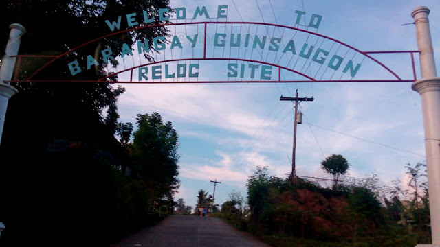
After Minoyho Bridge (San Juan - Saint Bernard boundary) is that welcome arch on the right side of the road. This is not where the deadly landslides occurred. It is way far from here actually. In this village (I mean a few meters walk going in there) is where the few that remains of them, the residents of the original Barangay Guinsaugon, were relocated.
This arch is just across the national highway from the beach facing Cabalian Bay - the southeastern-most area of Saint Bernard. The landslides happened way very far north in the boondocks of Mt. Cantabang, below which is/was the original Barangay Guinsaugon.
Now the cute thing.., this relocation site is/was actually part of Brgy. Magbagacay. But, since it's a whole community that relocated to this area, they now call this place the "New Brgy. Guinsaugon" (am not sure if that is "official"). It's complete with the New Guinsaugon National High School! Well, it's been almost a decade since the tragedy, but last I remember, this village had more than a hundred houses. They may not reach the 2,000 required minimum people in a barangay, but then again, many of them perished.
Anyway, I didn't go into the village. They were not the purpose of this trip. No more drama this time. I did not wish to hear again, the story of that elementary school actively conducting classes at 10:30AM when swallowed whole by rampaging mud earth and debris, and only a child and an adult were seen and rescued from the 246 students, 7 teachers and unknown number of parents/guardians outside the school, all buried alive.
Did not wish daw, eh inulit ang whole story... ayun drama rin ang kinalabasan! Let's go!
Anyway, I was just passing-by, to see the downtown areas like starting here...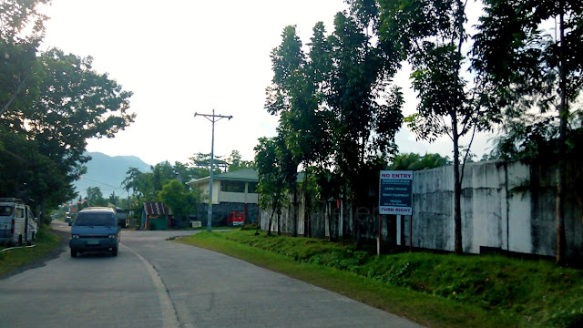 This is an important corner. Downtown Saint Bernard starts here (in my own view). This concrete fence on the right, you don't wanna go in there. That's the cemetery hehe. That green roof is the back side of one of the buildings of a high school I forgot the name of (Christ the king? or something). If you are driving, you choose where to go at this corner.
Turning right goes up to a circumferential road avoiding the downtown traffic (if any)! But don't worry if you are going to their municipal hall, you can enter it from its back gate near their municipal engineering office that looks like a cute 2-level native house!
We went straight as we know the church is just along this road, and from there is a street going up to the town hall. The commercial downtown is blocks away from them.
Here's some trivia: in the past, when the circumferential road was not yet built, going straight (the only way) was part of, and aptly called the national highway. Now it is just Torres Street. Because, the circumferential road became the national highway. Aliw hehe!
Okay, let's go to their cute church first. And that, is my next story!
==========================================
Click these numbers for a chronology of my notes:
01
02
03
04
05
06
07
08
09
10
11 12 13 14 15 16 17 18 19 20
21 22 23 24 25 26 27 28 29 30
31 32 33 34 35 36 37 38 39 40
==========================================
Or just click "Newer Post" or "Older Post" below.

After Minoyho Bridge (San Juan - Saint Bernard boundary) is that welcome arch on the right side of the road. This is not where the deadly landslides occurred. It is way far from here actually. In this village (I mean a few meters walk going in there) is where the few that remains of them, the residents of the original Barangay Guinsaugon, were relocated.
This arch is just across the national highway from the beach facing Cabalian Bay - the southeastern-most area of Saint Bernard. The landslides happened way very far north in the boondocks of Mt. Cantabang, below which is/was the original Barangay Guinsaugon.
Now the cute thing.., this relocation site is/was actually part of Brgy. Magbagacay. But, since it's a whole community that relocated to this area, they now call this place the "New Brgy. Guinsaugon" (am not sure if that is "official"). It's complete with the New Guinsaugon National High School! Well, it's been almost a decade since the tragedy, but last I remember, this village had more than a hundred houses. They may not reach the 2,000 required minimum people in a barangay, but then again, many of them perished.
Anyway, I didn't go into the village. They were not the purpose of this trip. No more drama this time. I did not wish to hear again, the story of that elementary school actively conducting classes at 10:30AM when swallowed whole by rampaging mud earth and debris, and only a child and an adult were seen and rescued from the 246 students, 7 teachers and unknown number of parents/guardians outside the school, all buried alive.
Did not wish daw, eh inulit ang whole story... ayun drama rin ang kinalabasan! Let's go!
Anyway, I was just passing-by, to see the downtown areas like starting here...

Turning right goes up to a circumferential road avoiding the downtown traffic (if any)! But don't worry if you are going to their municipal hall, you can enter it from its back gate near their municipal engineering office that looks like a cute 2-level native house!
We went straight as we know the church is just along this road, and from there is a street going up to the town hall. The commercial downtown is blocks away from them.
Here's some trivia: in the past, when the circumferential road was not yet built, going straight (the only way) was part of, and aptly called the national highway. Now it is just Torres Street. Because, the circumferential road became the national highway. Aliw hehe!
Okay, let's go to their cute church first. And that, is my next story!
11 12 13 14 15 16 17 18 19 20
21 22 23 24 25 26 27 28 29 30
31 32 33 34 35 36 37 38 39 40


Comments
Post a Comment