Macrohon Discoveries
Macrohon town proper is about 7kms on a northward run from Kuting Reef Resort which sits in one of its barrios. Though still gloomy, the ride was good with views left and right. Most of the road here is lined on both sides by trees that (I guess) were purposely planted to make their highway look beautiful. I also saw a couple of old wooden houses.
A portion of this road runs along a nice clean river. My driver says the mouth of that river empties at the beach near Kuting. Hmm, this could be an interesting future tourist draw. Other parts run along white sandy beaches that, I think, are even better than the sand at Kuting. I noted the villages of Villa Jacinta and Sto Nino. Nice views from the highway!
I wasn't able to snap a photo, but passing this way was also first time for me to see a "Multi-grade School" - whatever that means. The signage was "Aguinaldo Elementary Multi-grade School". What I only know is that elementary schools have multiple grades like 1, 2, 3, 4, 5 and 6. Alangan namang Grade 3 lang lahat di ba? I will ask around soon (or you my readers please comment below), on what is a meant by "multi-grade school".
I also saw signs that said "NO ENTRY, MEN & WOMEN AT WORK" - oh ha, gender aware! I guess those are part of the DSWD KALAHI projects. It's with them that I saw these signs starting to sprout all over the country. Kudos to that department in their GAD efforts!
Here's more, if in Padre Burgos I noticed that they have nice-looking barangay halls, in this town I observed that almost every barrio I saw along the highway had sizable and good looking chapels or churches. I don't know what's the difference. Is it by the size?
Anyway..,
We were in town, driver almost missed this intersection (since the signboard is faded)...It says going 400 meters to the left is Macrohon Proper, while to the right, following this highway is 13kms to Maasin City, the capital of this province of Southern Leyte. It is obvious in that pic, we swerved on a national highway going to that leftwards street. 😱
Hmm, I could sense driver was a bit lost on where we would find the municipal hall.We went cruising along this street (J. Rizal) which caused me to see a number of old wooden houses like this one. There are also two more at the corner with C. Kangleon St.
This Jose Rizal St. goes the length of town, turns a sharp right at some basketball court (still Jose Rizal Street) and goes out unto the national highway haha! We were lost! But that's the beauty of getting lost sometimes, right? We get to see the unexpected views!
So we backtracked, reaching front of that old house again. This time, we turned right at what looked like a multi-purpose or sports-something building, going towards that tree!Voila! We we were finally in the right place (we thought)! That smaller structure straight form the camera, to the right of that big tree is a barangay hall. Further to the right (not in picture) and bigger than that barangay hall is a chapel named San Vicente. That bigger structure to the left of the big tree is their rural health unit. We turned left there.
Woa, the place is big and wide, there is a park and a plaza to our right. And further right is the beach! There's even a monument that looked like Jose Rizal, his back to the beach.
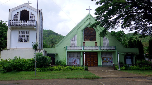
To our left we saw what looks like a chapel, but we realized is the town's main church.Kasi naman, all the chapels we passed by are so big they're almost as big (or bigger?) than this one! Even that San Vicente Chapel (which is just a few steps away btw) is big!
And... this one was locked, at 1:20PM on a Sunday, argh! So I just took this picture and marveled why that bell tower (that looks like there's no bell anyway) is so fat it is almost the width of the church. In fact, it's the only thing that makes this church look large!
But where's the municipal hall? We suspected it could be this modern-looking building.This is just a few steps from the church. But it does not look like it is already in use. It looks like construction is still in progress. Well, I surmised, yes this might really be their old municipal hall and currently being refurbished. Just guessing, no folks around to ask!
We were about to leave as I already took those two pictures above. But, driver chanced upon a man who was passing by in a bike, so out of curiosity (and just to make sure) he asked if this was the munisipyo. We were told it's up at the side of the highway hahaha!
Instructions (in English): "go straight; turn left at the corner behind this building; just follow that street all the way to the highway; then you will see our municipal hall"! Hmm, I think the manong was/is a teacher. He preferred talking in English than bisaya.
So, instructions memorized... we went for it!
And there it is.., that building in there.., behind Ruperto Kangleon!I was just able to snap this picture and it started to drizzle again. Haizst! Anyway, I must repeat, that is Kangleon's statue not Rizal - because they look a bit similar. Magkahawig!
Do you know Ruperto Kangleon? Ako rin hindi hehe! I do know a military camp in Palo is named after him. So he must have been a military man. But now I know he was born in this town, studied at what is now PMA, was secretary of defense, governor and senator.
See? Travel is education!
I was not to be deterred by the rain though. I still took this picture without Kangleon.This was what I sought to see, so this is the: Macrohon Municipal Building, Leyte Del Sur.
Then on with the northward trip. This time, to the city - Maasin!
But 8kms after the municipal hall, we were still in Macrohon, and I saw this...Nice fence. As in "pader talaga". But, Sumayod Pensionne? I wondered why there was this Pensionne in the middle of nowhere. Driver told me we were still some 10kms before Maasin City. Hmm, the last group of structures I recall we passed by, was the Macrohon Cemetery hehe. So I said, ah maybe a bit forward is a populated industrial or tourist area.
I spoke too soon! Just a few breaths more we passed by another two cemeteries - across each other pa, on the national highway! One is called Assumption Gardens (a private memorial park, I guess) and directly across is Ichon Public Cemetery. But those aren't pensionne house markets, di ba?! Well, as I always say, "walang basagan ng trip"! Duu!
Speaking of Ichon...
I thought we were in a town called Ichon - as this one is a big place. But something inside me was protesting - that I have never heard (yet) of a town in Region VIII named Ichon. I asked the driver, he said this is just one of the barangays of Macrohon.
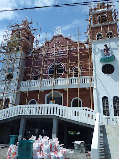
What surprised me though was, Ichon even has its own central school, police station and (this photo) its very own catholic parish! We did not stop here, but this façade alone is probably the height of a 3-storey building. Reason why this pic is in portrait orientation as it won't fit in my phone's viewfinder.
This is a big church. Definitely bigger than the one at Macrohon town center (mentioned above). And if you can read the signage on top if this church, it says "Parish of Ichon, Diocese of Maasin".
Moreover, just a quick glance around as we passed, I saw that there is a scattering of big old wooden houses here too. So, this place must have been some kind of a town center or poblacion in the past, I guess. In fact, this place seems to be even more commercially bustling than at the 'real' poblacion or 'town proper' of Macrohon that we came from.
Interesting finds!
After Ichon we were already in Maasin. But something happened. That's my next story!
11 12 13 14 15 16 17 18 19 20
21 22 23 24 25 26 27 28 29 30
31 32 33 34 35 36 37 38 39 40


Nice... I miss my hometown just few steps from Municipal building.
ReplyDelete