Burauen to La Paz
I left Burauen and moved onwards to La Paz, still using the nice provincial roads.
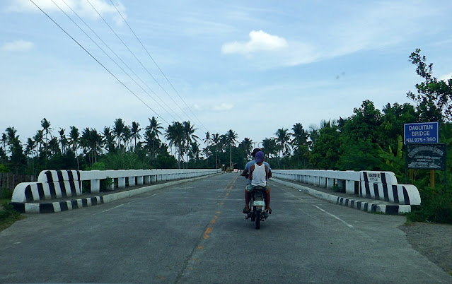
While exiting town center, just two minutes from the church, I passed by this bridge...I was praising how good (and new?) this bridge was, when something made my chinky eyes open wider. The name: Daguitan Bridge. I said to my self "how is that possible"?
I thought this might have been mislabeled as I know of another bridge (in Dulag) that is also named Daguitan Bridge. I was sure too, that it is not this one, since, that "other" Daguitan Bridge is longer, and there is something there that fascinates me (story later).
Things played in my lowly mind, until I silently calmed my royal self, that both bridges are named "Daguitan Bridge". Well, if towns can have "same names", so would be bridges!
Still on Daguitan Bridge (in Burauen), I looked down and saw some kind of a mini-dam..Not sure what it is, but it looks like a dam to me, micro size nga lang hehe. A similar thing I saw would be somewhere in Montalban (Marikina River), where we walked on it as if it were some kind of a foot bridge (na concrete). Anyone please tell me what that is.
Now this is "cute": at the end of Daguitan Bridge, the road is narrower than the bridge...That would be contrary to our usual complaint in this country, right? Well, there it is, so I just thought, maybe the DPWH made this bridge already wide enough, in time for a road widening - which may, or may not necessarily be in our lifetime hahaha! Eh, as I see it, parang bago lang ang kalsadang ito eh, mag-widening na agad? But who knows, di ba?
But I like this road. Few vehicles passing. Most are just DPWH equipment, and dogs!Oh, I saw on some signage, this road is named "Jaro-Dagami-Burauen-La Paz Road". Woa! Very nice alternative road than passing via the national highway (N686?).
Anyway, and then I saw this... whatever could this be, I don't know (yet) heheAm not an engineer, so I don't have any idea what those are and what for. The thing is, I just did not expect to see such an "industry" in this remote an area. I'm learning though!
Moving on, Marabong Bridge, still part of Burauen, another nice-looking (new?) bridge...But a bit of 'scary', even my driver shook his head. Look at the far left (where men in bikes are), part of this bridge seems to have sunk - I hope it's not anymore sinking! You can even see it by looking at the left side barrier, it curves down at that portion. Duu! Kulba!
Nothing of note here, except that I needed to take photo of the barangay's name...Why? Because somewhere ahead, is the road where one turns right going to Mahagnao National Park. And what a coincidence, I missed that corner. Basta, it's in this barangay!
And finally, Hibuga Bridge... the boundary between Burauen and La Paz Leyte!Teka, why does it seem that this has been a bridge-sighting part of the trip? Ah, pardon the obsession hehe. I was just fascinated that the roads and bridges here, though a 'back-country' road, were unexpectedly good.
So, let's enter La Paz next!
==========================================
Click these numbers for a chronology of my notes:
01
02
03
04
05
06
07
08
09
10
11 12 13 14 15 16 17 18 19 20
21 22 23 24 25 26 27 28 29 30
31 32 33 34 35 36 37 38 39 40
==========================================
Or just click "Newer Post" or "Older Post" below.
While exiting town center, just two minutes from the church, I passed by this bridge...I was praising how good (and new?) this bridge was, when something made my chinky eyes open wider. The name: Daguitan Bridge. I said to my self "how is that possible"?
I thought this might have been mislabeled as I know of another bridge (in Dulag) that is also named Daguitan Bridge. I was sure too, that it is not this one, since, that "other" Daguitan Bridge is longer, and there is something there that fascinates me (story later).
Things played in my lowly mind, until I silently calmed my royal self, that both bridges are named "Daguitan Bridge". Well, if towns can have "same names", so would be bridges!
Still on Daguitan Bridge (in Burauen), I looked down and saw some kind of a mini-dam..Not sure what it is, but it looks like a dam to me, micro size nga lang hehe. A similar thing I saw would be somewhere in Montalban (Marikina River), where we walked on it as if it were some kind of a foot bridge (na concrete). Anyone please tell me what that is.
Now this is "cute": at the end of Daguitan Bridge, the road is narrower than the bridge...That would be contrary to our usual complaint in this country, right? Well, there it is, so I just thought, maybe the DPWH made this bridge already wide enough, in time for a road widening - which may, or may not necessarily be in our lifetime hahaha! Eh, as I see it, parang bago lang ang kalsadang ito eh, mag-widening na agad? But who knows, di ba?
But I like this road. Few vehicles passing. Most are just DPWH equipment, and dogs!Oh, I saw on some signage, this road is named "Jaro-Dagami-Burauen-La Paz Road". Woa! Very nice alternative road than passing via the national highway (N686?).
Anyway, and then I saw this... whatever could this be, I don't know (yet) heheAm not an engineer, so I don't have any idea what those are and what for. The thing is, I just did not expect to see such an "industry" in this remote an area. I'm learning though!
Moving on, Marabong Bridge, still part of Burauen, another nice-looking (new?) bridge...But a bit of 'scary', even my driver shook his head. Look at the far left (where men in bikes are), part of this bridge seems to have sunk - I hope it's not anymore sinking! You can even see it by looking at the left side barrier, it curves down at that portion. Duu! Kulba!
Nothing of note here, except that I needed to take photo of the barangay's name...Why? Because somewhere ahead, is the road where one turns right going to Mahagnao National Park. And what a coincidence, I missed that corner. Basta, it's in this barangay!
And finally, Hibuga Bridge... the boundary between Burauen and La Paz Leyte!Teka, why does it seem that this has been a bridge-sighting part of the trip? Ah, pardon the obsession hehe. I was just fascinated that the roads and bridges here, though a 'back-country' road, were unexpectedly good.
So, let's enter La Paz next!
11 12 13 14 15 16 17 18 19 20
21 22 23 24 25 26 27 28 29 30
31 32 33 34 35 36 37 38 39 40


Comments
Post a Comment