Tacloban To Tandag By Air
Is there such a thing? None! But it can be done via connecting flights, without touching MNL, which is what I did! Travel time was about 9hrs, including transit time. My calculator says this would have been about the same duration if I traveled by land. But this time, flying was more comfortable, and cheaper!
Here's how it went..,
I took the Cebu Pacific early morning flight from Tacloban to Cebu. This photo taken at 0538H! If at 5:38AM I already clicked this photo, imagine what unholy time at dawn I must have awoken.., and what time I must have taken a bath, left home and so on! Hmm, what time did I sleep last night? Did I?
At 0616H, morning still misty, my plane was already on a take-off roll. Of course I was still groggy!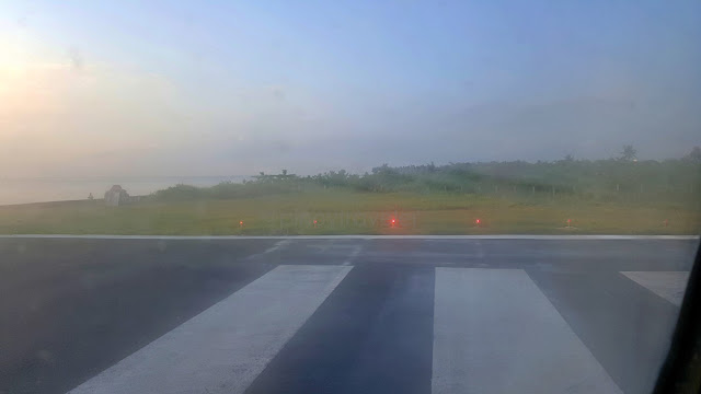 Oh, if you notice a pinkish glow on the left edge of the pic, it was a sleepy Mr. Sun attempting to shine!
Hey, it's late at night now as I write this, and I laughed at seeing my video clip during this take off run! I will put that somewhere here when ready. I don't know.., maybe my phone was also still sleepy.., or my hands were still lazy, or maybe the pilot was still sleepy! The video shook like I was riding on a horse!
If it was/is any consolation.., at least I got to see (a part of) Tacloban on a gloomy start of day! I like the reddish tint from the sun, and some houses with lights still on.., but, is that smog I see? Ahh!
The fluffy cloudy-clouds were also up and about minding their business of being, well.., clouds hehe! But maybe they too were also still groggily sleepy! They weren't as bright (yet)! But, good for my eyes!
At 0650H, yes after just 34 minutes, here we were above the Mactan Channel, getting ready to land. Those big ships are also still in deep slumber.., nothing is moving.., a conducive morning to oversleep!
Eto ka na Aling Amelia.., my connecting flight, Cebu to Tandag, flies at noon pa! More than 4 hours of free time. Da, niuli ko! Tulog ba ulit? No no no, baka sumobra, delikado! A very short time for labadami too! So, namalansa with some silhig silhig after puto-sikwate sa Mercado Lacion then back to airport!
Lunch was decidedly had at the airport - to ensure the airplane won't leave me behind hehe Grabe pila sa Jollibee, so I had CPA(Chicken-Pork Adobo) ilang Cesario. Mahala pud oi! Arroz Caldo at the Mabuhay Lounge (plus a little snooze time sana) would have been fine. Unfortunately, I was flying on the yellow planes today. O yes, as of now, only the small yellow planes (Cebu Pacific) fly to Tandag!
Did you know?
This route I took (Cebu to Tandag Flight) just started sometime middle of 2014, and only 3X/week by Cebu Pacific on their small ATR planes. Let's hope this (at least) stays this way longer, if not forever!
Actually, in the past.., I mean way way past as in the '60s to late '80s PAL had regular flights that flew to Surigao, Tandag and Bislig Cities all of which are on the northeastern part of Mindanao. I even still remember their 3-letter airport codes: SUG, TDG and BPH, oh ha?! They have ceased hence except for Surigao City, but with the addition of flights direct to Siargao. As for Tandag, Cebu Pacific dared to re-open the route. Let us hope they earn on this (CEB-TDG-CEB) - so flights will keep coming and going!
As for Bislig, no flights seem to be in the offing yet - aamagin muna ang airport nila for a longer more time hehe. Unless a sudden influx of national or international tourism and/or businesses gets to peak further in these areas, and, Davao Oriental. In fact, kung ako, I would've re-opened Bislig than Tandag!
Kuro-kuro ko lang yun - eh sino ba ako for airline owners to listen to me hehe! Okay, back to my flight!
Alright, at 12:17NN, my (connecting) flight from CEB to TDG was already taking off at Runway 04. But as always, my eyes kept darting to that Terminal-2-in-the-making (red arrow). It'll rise in that area (you can see the crane at the left edge of the pic) and hopefully make air travel to/from Cebu become a little more 'respectable' - I don't yet even wish to say 'comparable' to other ASEAN airports. But sana!
Oh the blue arrows point to the present length of the MCIA (both domestic and international) inclusive of the tingi-tingi extensions at both ends. The whole thing is already too small, even for local travelers.
Takeoff! Those big roofs are locator companies of MEPZ1 (Mactan Export Processing Zone 1)..,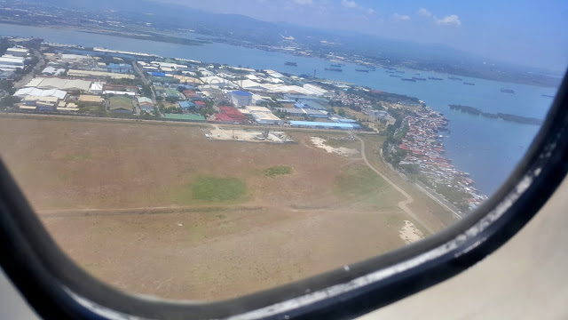 Many of those locators are big names in their own fields. Like which companies? Well, I remember the following: Timex, Kenko, Taiyo Yuden, ON Semiconductor, Lear Corporation. There is even a company that manufactures bullet-proof vehicles used by heads of state and royals around the world. BUT, they do not have any Pinoy customers (daw) because their products are so expensive no Pinoy can afford!!
Nice day, and my airplane continued climbing.., now banking to the right, so it can go southwards.., That wash of white on the water is a fastcraft entering Cebu. Golly how they look so small from up in the air 'no? Ah, do you see the red arrow? It points to the "parola" (lighthouse) at Bagacay Point, Brgy. Catarman, Liloan. Why is that vital? Ah, it is historical, and steps away from my future home! So, vital!
Anyway..,
Since Tandag is below Surigao City, my flight banked to the right from Mactan, heading south-east. See those islands? Those are north of mainland Bohol -- all of them belong to the town of Bien Unido. Nice island views as the flight glided by, going to the right, southwards to the tip of the island of Leyte.
Here is Gaus Island - part of a town with a very long name: Municipality of President Carlos P. Garcia! It's pronounced as "Ga-oos", okay? Not "Goss" or "Gaws"! Brgy. Gaus is 1 of 13 islands of this town. By the way, no one calls the town with just "Garcia". It's always the full President Carlos P. Garcia. They're careful not to muddle things, as there's another town in this province that is called Garcia Hernandez!
Oh while we're on this topic, President Carlos P. Garcia was a Boholano alright, he was born and grew up in Talibon - two towns to the left of this town that was named after him. Maybe he did great things in/to Pitogo (old name of the town) that made the people convert their town's name in/to his memory.
But did you know that the president was a full-blooded Abreño? Yes, his parents were from Bangued!
Oh oops teka wait kadyut! I am so talkative we're going far to Abra hahaha! Back to my flight, okay?!
Still flying over Bohol, I could see on my distant left the haze of a big island that should be Leyte.., That one, below the clouds, should probably be in the area of Cabulihan and/or Santo Rosario leading right (to the edge of the photo) which would be the center of Maasin City, Southern Leyte. OMG really? At times, kinikilabututan ako at the many places I can identify for having been to many of them. Gosh!
And this one (left edge of rectangle) is the tip of mainland Leyte (Padre Burgos) facing Limasawa.., It is not very clear, but someone taught me how to tweak the same photo so it shows the two islands
 But I still don't like it hahaha! Anyway basta, that's supposed to show Limasawa Island. Yes, that is it!
Then my plane started hovering over Mindanao.., yehey! Oops why am I celebrating? That is Tubay.., Tubay, Agusan Del Norte, a mining town. That brown thing in the middle of the photo - even wider than the town center to its right - is the SRMI or San Roque Metals Inc. Depending on who you talk to, SRMI is either famous or infamous. Well, in my simple mind.., mining is destruction of nature, therefore bad.
Oh, as if that is not enough, to the left edge of the pic is Agata Mining Ventures Inc.! Another such big destruction of nature. I even already have a "private joke" that I tell folks inviting me to visit this town.
I say I avoid those mines because of "negativity". Imagine: SRMI started at or proliferated from Brgy. Binuangan. Da, nabuang na! And AMVI starts at Brgy. Tinigbasan! Do you know what "tigbas" means?
I'm not superstitious, but Tubay, that has 13 barangays, is superstitiously "nega" 'no?!
Okay, enough of negativities hehe, so my flight crossed the mountains to the other side of the land. Just guessing, that body of water on the horizon should probably be Lanuza Bay or therearounds.
And we reached the pacific coast! Yehey! Tandag City is below and to the right of the plane!
There! That's the good old Tandag poblacion! My plane was making a u-turn to approach the runway!
Final approach (to the runway) from the east (pacific ocean).., Tandag, here I come.., I could see the beaches of Tago (Tago River too), all the way to the towns of Bayabas and Cagwait!
Exciting! After almost 3 decades, here I was, landing back at the Tandag Airport.., yeyeyeah!
From the plane's window, I could see the airport has been spruced-up but generally still the same..,
Ayan ayan.., I followed my fellow passengers to the arrival area! That other door at left is departure!
And from the arrival area's exit door, I saw what I thought was a hotel. OMG, this is City Hall na pala!
Last look at the airport, as I rode a tricycle going to the Balilahan Bus Terminal and onwards to Bislig Oh, did I not say that in my stories up above? Yes, this was a trip to Bislig, but the flying segment was just from Tacloban in Leyte, to Tandag in Surigao Del Sur. The rest of the way, as planned, was by bus!
So my trip has not ended yet! But let's discuss that next!
========================================
Click numbers for a chronology of stories on this trip:
01
02
03
04
05
06
07
08
09
10
11 12 13 14 15 16 17 18 19 20
========================================
Or just click "Previous" or "Next" below.
Here's how it went..,
I took the Cebu Pacific early morning flight from Tacloban to Cebu. This photo taken at 0538H!

At 0616H, morning still misty, my plane was already on a take-off roll. Of course I was still groggy!

Hey, it's late at night now as I write this, and I laughed at seeing my video clip during this take off run! I will put that somewhere here when ready. I don't know.., maybe my phone was also still sleepy.., or my hands were still lazy, or maybe the pilot was still sleepy! The video shook like I was riding on a horse!
If it was/is any consolation.., at least I got to see (a part of) Tacloban on a gloomy start of day!

The fluffy cloudy-clouds were also up and about minding their business of being, well.., clouds hehe!

At 0650H, yes after just 34 minutes, here we were above the Mactan Channel, getting ready to land.

Eto ka na Aling Amelia.., my connecting flight, Cebu to Tandag, flies at noon pa! More than 4 hours of free time. Da, niuli ko! Tulog ba ulit? No no no, baka sumobra, delikado! A very short time for labadami too! So, namalansa with some silhig silhig after puto-sikwate sa Mercado Lacion then back to airport!
Lunch was decidedly had at the airport - to ensure the airplane won't leave me behind hehe

Did you know?
This route I took (Cebu to Tandag Flight) just started sometime middle of 2014, and only 3X/week by Cebu Pacific on their small ATR planes. Let's hope this (at least) stays this way longer, if not forever!
Actually, in the past.., I mean way way past as in the '60s to late '80s PAL had regular flights that flew to Surigao, Tandag and Bislig Cities all of which are on the northeastern part of Mindanao. I even still remember their 3-letter airport codes: SUG, TDG and BPH, oh ha?! They have ceased hence except for Surigao City, but with the addition of flights direct to Siargao. As for Tandag, Cebu Pacific dared to re-open the route. Let us hope they earn on this (CEB-TDG-CEB) - so flights will keep coming and going!
As for Bislig, no flights seem to be in the offing yet - aamagin muna ang airport nila for a longer more time hehe. Unless a sudden influx of national or international tourism and/or businesses gets to peak further in these areas, and, Davao Oriental. In fact, kung ako, I would've re-opened Bislig than Tandag!
Kuro-kuro ko lang yun - eh sino ba ako for airline owners to listen to me hehe! Okay, back to my flight!
Alright, at 12:17NN, my (connecting) flight from CEB to TDG was already taking off at Runway 04.

Oh the blue arrows point to the present length of the MCIA (both domestic and international) inclusive of the tingi-tingi extensions at both ends. The whole thing is already too small, even for local travelers.
Takeoff! Those big roofs are locator companies of MEPZ1 (Mactan Export Processing Zone 1)..,

Nice day, and my airplane continued climbing.., now banking to the right, so it can go southwards..,

Anyway..,
Since Tandag is below Surigao City, my flight banked to the right from Mactan, heading south-east.

Here is Gaus Island - part of a town with a very long name: Municipality of President Carlos P. Garcia!

Oh while we're on this topic, President Carlos P. Garcia was a Boholano alright, he was born and grew up in Talibon - two towns to the left of this town that was named after him. Maybe he did great things in/to Pitogo (old name of the town) that made the people convert their town's name in/to his memory.
But did you know that the president was a full-blooded Abreño? Yes, his parents were from Bangued!
Oh oops teka wait kadyut! I am so talkative we're going far to Abra hahaha! Back to my flight, okay?!
Still flying over Bohol, I could see on my distant left the haze of a big island that should be Leyte..,

And this one (left edge of rectangle) is the tip of mainland Leyte (Padre Burgos) facing Limasawa..,


Then my plane started hovering over Mindanao.., yehey! Oops why am I celebrating? That is Tubay..,

Oh, as if that is not enough, to the left edge of the pic is Agata Mining Ventures Inc.! Another such big destruction of nature. I even already have a "private joke" that I tell folks inviting me to visit this town.
I say I avoid those mines because of "negativity". Imagine: SRMI started at or proliferated from Brgy. Binuangan. Da, nabuang na! And AMVI starts at Brgy. Tinigbasan! Do you know what "tigbas" means?
I'm not superstitious, but Tubay, that has 13 barangays, is superstitiously "nega" 'no?!
Okay, enough of negativities hehe, so my flight crossed the mountains to the other side of the land.

And we reached the pacific coast! Yehey! Tandag City is below and to the right of the plane!

There! That's the good old Tandag poblacion! My plane was making a u-turn to approach the runway!

Final approach (to the runway) from the east (pacific ocean).., Tandag, here I come..,

Exciting! After almost 3 decades, here I was, landing back at the Tandag Airport.., yeyeyeah!
From the plane's window, I could see the airport has been spruced-up but generally still the same..,

Ayan ayan.., I followed my fellow passengers to the arrival area! That other door at left is departure!

And from the arrival area's exit door, I saw what I thought was a hotel. OMG, this is City Hall na pala!

Last look at the airport, as I rode a tricycle going to the Balilahan Bus Terminal and onwards to Bislig

So my trip has not ended yet! But let's discuss that next!
11 12 13 14 15 16 17 18 19 20


Comments
Post a Comment