Out Of Panglao To Davao, Cebu And Tacloban
This was another fun-flight-day. Meaning? Ah, another circuitous route from Point A to Point B. Yey!

This first leg of the route was a "new to me" flight, a direct service on PAL from Panglao to Davao. Was I excited? "Very", to say the least! Why? Well, because this route is rather new. PAL started on this only in November 2017 with a 4x per week flight, then they made it once-a-day schedule since March 2018.
Convenience both for international and domestic passengers who want to hop directly between these two tourist capitals -Bohol and Davao- without the need for backtracking to say, Cebu or even Manila.
Let's go na!
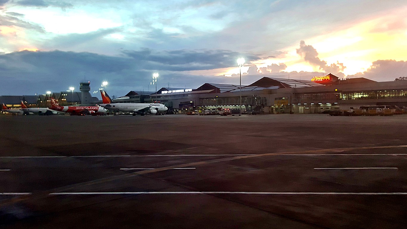
Departure From The New Panglao International Airport
Bye Panglao's New Airport!Pushback! Aw, not literally push-back. It was more of a "forward and turn" - because it's so wide here! Our plane, a Q400, did not need to be towed out. It just moved forward a bit and turned. Maluwag eh!

If you remember one of my last stories about that old Tagbilaran Airport, the tarmac space there was good for only one big and one small airplane hehe! This new facility is, I think, probably 10x the area.
Did you notice the tarmac cement is reddish? I am guessing that is the natural earth color (lupa/yuta) in this area which they used. You saw that in my arrival video, I'll put one again below for this takeoff!
Takeoff From Runwa 03 Of Panglao International Airport
Takeoff!And off our Q400 aircraft taxied to the end of Runway 03 (southern end) for our takeoff run.

I noticed though, there is no real taxiway (yet) since we taxied on the runway itself.

And off we were from Bohol!
Dauis Town, Panglao Island, Bohol
Dauis From The Air!This is the town of Dauis below us. Across it is Tagbilaran city proper.

Hey, somewhere near the middle of that photo, you should see a white dot (that's the circular roof of a resort). Somewhere to its left is the Hinagdanan Cave, which is usually a part of day tour itineraries!
Across the island, the fuzzy (cloudy) top-half of that photo, is Tagbilaran city proper. We already know that Panglao is connected to Tagbilaran via two causeway-bridges, right? I saw them from the sky. Yey!
I really wanted to take a picture of those 2 causeways down there, but I saw them only briefly, before I could aim my camera, since the plane already banked sharply to the left, heading south to Mindanao.
In my hope to watch more of "down there" as we took off, I even tried looking from the window across me (left side) while our plane tilted that way but the passenger on that side blocked most of my view!

That's my interpretation of him. I was/am judging the book by its cover. Ganun!
Aerial Views of Pontod, Gac-ang and Balicasag Islands
Bird's-Eye-View of the Tourist Islands!After that "u-turn in the air" going south, another clearer aerial view of Panglao's island attractions!


Note: Between Pontod and Gak-ang, there's like a cloudy white streak that looks like a line. It's also a sandbar that's only visible with a dry sand area during low tide. There are many of those in that area.
Note too: everywhere in that Panglao Reef are a scattering of fine dive or snorkeling sites, it depends on how experienced your dive and/or tour operator is. So 'choose wisely' if you want to explore there!
And that's not even all! To the left of that photo (that would be "south of Panglao Island") is actually a Dolphin and Whale-watching corridor. They are normally packaged with a Balicasag visit or vice-versa.
Wow! Truly amazing! I was just flying from Bohol to Davao and I saw fantastic places I didn't even plan to see! The advantage of flying with smaller (propeller) airplanes. They fly low and slow, we see more!
My final note on that bird's-eye-view of the Panglao Reef Area.., that is a rare sighting for us travelers.
Why rare? Because if you fly from Panglao (still called Tagbilaran by the airline industry, btw) whether to Cebu, El Nido, Coron, Manila, Jeju or Incheon, which are all northwards, chances are, you won't have that 'cool sighting' I just had above, even if your flight took off via Runway 21 (as you will be too near).
The best chance is flying on a Mindanao-bound flight like Davao, where the plane makes a Runway 03 takeoff (that's northwards) then "u-turns" heading south. (Hey I heard TAG-CGY flights are coming too)
Approaching Mindanao From Bohol By Air
Mindanao Here I Come!Anyway, this hop had an interesting flight path - going south to "above Iligan", then east to Davao.

With a 'low and slow' aircraft, more great views for me! This was approaching mainland Mindanao.

Panguil Bay Aerial View
Panguil Bay From The Air!Here's that mouth of Panguil Bay, as my flight cruised eastward. I wished we flew closer in there.

Iligan City Aerial View
Iligan City From The Air!Here is a bird's-eye-view of Iligan City anyway, also a rare sight for us passengers traveling by air.

Does it? Well, good luck to all who reside in Iligan, Lugait and nearby areas.
Lake Lanao and Marawi Aerial Views
Lake Lanao and Marawi From The Air!The low-flying plane kept-on eastward. And I had another wonderful view, this time of Lanao Lake!

Hey that's the entirety of Lake Lanao that I saw (clearer with my bare eyesight than by the camera)! It may not be better than a googlemap image, but it was my 'live capture'. And that makes me feel good!
Looking down reminded me of the many towns on the east-side of that lake (the left side in that pic). They're all in my 'bucket list' because I don't hear much about them. They have interesting names too!
Have you heard of Ditsaan-Ramain? How about Buadiposo-Buntong or Lumba-Bayabao? Those are all towns by the lake, and their "official names" are noticeably "dashed". Parang Ponce-Enrile ang dating! Yet there's also a town named "Poona Bayabao", without a dash. Town names pa lang, curious na ako!
If I/we visit the area, we might actually learn what really is a "shakba"? So, still bucket-listed!
Mt. Apo Aerial Views
Was This Mount Apo?After 18 minutes of that southeastward cruise, I saw a very wide expanse of high hills and mountains.


Weh, I do not know how it looks from up above while flying on an airplane. If I base it on the time we traveled so far though, we might have been in the Cotabato/Davao Del Sur area. So, that could be "it"!
Yes pwede.., it could be "that" hehehe! Whatever, wherever, Mt. Apo or not, I must say my mountaineer friends just earned another notch of high respect from me, for doing what they do - climb mountains.
Grabe ang taas nyan, walang kalsada, inaakyat nila! Tapos pagdating sa tuktok, bababa pa. Butlaw!
Davao City Aerial City Tour
Ito Ang Mala-Agila Na Tour Ng Davao!Anyway, as if to confirm it was really Mt. Apo that I saw.., after 4 minutes, this was the view... Davao!

Actually, if your eyes could discern it, the upper portion of that picture is an expansive ascending wall of nature, because that is mismo already a portion of the foot of the south-eastern slopes of Mt. Apo!
Here, we were already banking left to align with the runway, that's why you now see the sea at left.

That would only be (probably) 5 minutes on this landing approach!
Still banking left, I got a shot of this "corner in the air". I was sure we were already above Matina.

In fact, the airplane was directly above the Sto. Niño Shrine (Shrine of the Holy Infant Jesus of Prague, a.k.a. "Grotto"), that is why I could not see it. And look at the bottom of the picture, the whitish roofs on a lush green hill (that's why they are nearer to the camera) are the buildings at/of/on Jack's Ridge!
Memories memories! Though I now can't recall how many times I have been up at Jack's Ridge since it opened many kupong-kupong years ago! We were already frequent visitors of that hill (grotto), before Jack's Ridge came to be. The memorial parks, and establishments down there, weren't yet around too.
Everywhere were just big trees, you won't even see DBP Village. Karon, tua ra ang balay ni Doktorita o!
Okay. Still far from the runway, but this was such an awesome fly-by along the length of Davao City!

I could also see Ateneo De Davao 'bagets campus'. I call it that since it's only for the grade school and high school departments. I heard they opened another campus (for senior high school) somewhere in Bangkal Dsitrict, but I haven't seen that yet. I guess that's where my plane earlier started to bank left.
Still on that picture above, which you should also see in the photo below, let us cross to the left bank of the river, and continue our aerial tour of Davao City! Kaya okay ang landing na ito, parang tour nga!
I could see Bankerohan Market. It's right after the bridge. If you haven't yet visited that public market you should. I think it's the only public market in Davao City that has everything - especially the fruits!
You can buy just a piece, a kilo or even crates of whatever you see. It's their "go-to" place if they want to sell or buy quality fruits of the season. Something like a "bagsakan" and retail market in one place.
Aw, you should try visiting those that sell fruits by the crates. If you're lucky (I assure you, you will be anyway!), vendors may toss you a piece or two of those fruits, for no reason at all, and for free. Libre!
Some will say "tilawi sir, masarap yan", but most of them won't even say anything other than a smile!
The cemeteries (yes plural, on foreground of the picture) are prominent on this landing path. Da!

It's a must for visitors to check-out that 'original' central area of the city. Their Metropolitan Cathedral is there, so are the many historical edifices and areas of the old Davao City. Colasa's is also still there!
Speaking of tall buildings, Davao doesn't (yet) have many skyscrapers (and I like it) that's why it's easy to identify anything that sticks out into the sky like the Royal Mandaya Hotel Building, the Marco Polo and Ateneo De Davao Main. I could see them all as my plane zoomed down to the airport's Runway 05
Oh, beyond the city center and out into the Davao Gulf, although just a haze in the picture, you would see the outlines of Talikud Island and parts of its mother island IGaCoS (Island Garden City of Samal).
Anyway.., I promised to put a video clip, so here it is...
Landing, Arrival and Transit at Davao International Airport
Madayaw Dabaw!That was a unique 'rolling tour' of almost the entire south-to-north length of Davao. And we arrived!

Yes, we had to walk on the tarmac to the arrival area as this flight was on a tiny Q400 propeller plane.

Hasta la vista na? No! I still have more stories to tell!
I was just transiting at Davao Airport, remember? If you check the first image above, this was only the first of 3 interconnected flights. I was immediately flying to Cebu then onwards to Tacloban all on PAL!

Let's arrive at, and depart from Davao (Francisco Bangoy) International Airport.
Arrival is still the same at this airport. Orderly. Nothing much has changed, for many years now...

Kudos to them! Sana forever and sana all! [Oist Cebu & Davao Airport Staff, wag nyo ako pahiyain ha?]
At other airports, mapipikon ka, me tao nga minsan, pero hindi naman sila official airport information staff. Madalas ang andun yung nag-aalok ng coupon taxi service. Asus, pati sa Brunei, ganun din hehe!
Now... you might say that those information counters are not really that important anyway. True if you are a resident or frequent visitor of the city. But for first-timers those are "very essential must-haves".
In fact, information also now abounds on the web. But, why put up a counter when it's not going to be manned? Besides, bayad ka ng bayad with government money to people who don't do their work? Da!
So, still hats off to Davao (and Cebu) for being good examples!
If there is anything I don't like here... they have succumbed to the style-budget-airline na kahit saang sulok na lang ng kahit ano nilalagyan ng advertisements. Okay sana kung tourism ek ek lang ng LGUs.

Hmm, saan kaya napupunta ang kita ng airport sa mga ads na yan? Operations & Maintenance? Bakit, kulang pa ba ang terminal fee travel tax at kung anuanong tax na inaambag natin sa gobyerno? Kaha?
Ganyan na ba ang style ng gobyerno ngayon? If so, pati city hall, capitolyo, congress, senado, supreme court tadtarin na rin ng ads! Nababawasan ang dignidad ng gusali (bakit meron ba in the first place?)!
Those ads are pampadagdag sa stress levels ng mga pasahero. There had been studies on that.
Ay, let's not be stressed hehe! I did not go out of this arrival area. No need, since I was just in transit.


Bahala na you if you want to "shop-till-you-drop"! Basta, if you are just transiting in Davao, no need to go all the way out to the arrival curbside. Just pass by that small door to the left!
Note that it doesn't really 'physically' save you on anything as you will have walked the same distance and you will still go through the same security check (x-ray) procedures like other passengers who are not in transit. Hindi ka nga lang lumalabas ng building! There is no 'Transfer Desk' (yet) in this airport.
Domestic Check-in at Davao International Airport
Check-in!And I still visited the PAL check-in counter, as my DVO-CEB boarding pass was not issued at Panglao.

As I showed on that google map at the start of this article, I had three (3) connecting flights: TAG-DVO, DVO-CEB and CEB-TAC. Natulala ng sandali si Inday nang makita nya ang ticket ko! Ang normal kasi is, they see passengers with only two connected flights within the day, so they issue 2 boarding passes.
When I checked-in (at Panglao airport), I asked for boarding passes for the 3 flights - which is seldom. She initially said "wait sir, di ko alam kung pwede ito". I told her "pwede yan". Pause... nag-loading pa ang iyang brain entawon! I didn't ask, so I wasn't sure if her confusion was procedural (is she allowed to check a passenger in, to 3 successive flights?), or technical (how do you do that on the computer?)
My solution was: "it's okay, I'll just ask for two boarding passes in Davao. All flights are web-checked-in na naman"! That's why I saw the above counter, and got my DVO-CEB and CEB-TAC boarding passes!

PAL Mabuhay Lounge, Davao
Lugaw Time Again!Make the long story short, I then found my way to feast on "arroz caldo" etc., at the Mabuhay Lounge.

Conversations are always hushed - walang KSP or bungangera or insik na humihiyaw sa cellphone nya (naka-sinelas pa); passengers don't have tons of handcarry items at inilalagay pa isa-isa sa mga silya; and when they stand or walk... me breeding, me karats ang arrive. Ewan ko ba, nagkakataon lang yata!
But I must say, this lounge is already too small for the number of passengers that avail of its services. Shout out sa mga kinauukulan - a bigger (I mean "wider") Mabuhay Lounge at Davao's airport, please!
Let's proceed!
Flight Boarding, Davao International Airport
Boarding!After about 2 hours of whiling my time away in Davao, it was time to board my Airbus flight to Cebu.


That plane I flew on earlier from Tagbilaran to Davao only seats about 80 humans!
Here... this was my ride to Cebu, RP-C8610, an Airbus A320-214, delivered brand new to PAL in 2007!

Oh, for the curious: that Cebu Pacific plane, RP-C3243 is a similar Airbus, with a seating capacity of 179, delivered to them (also new) in March 2007. Mas matanda yan ng 7 months, kasi yung RP-C8610 ng PAL was delivered November of the same year. As if it matters ano? Oh well, for your 'additional info' lang!
About Airport Aerobridge or Jetway
The Aerobridge!Let's talk about that aerobridge a little - because I had a clear full length shot of that thing this time - from where it is connected to the building's gangway (right edge), to where it attaches to the aircraft.
Aerobridges or airbridges are generally long, from 20 meters to (sometimes weirdly) about 70 or even more meters. When not in use, segments (or "tubes") are retracted (like in a telescope or antenna) to become shorter - that's why they have wheels in front for that needed movement. Aliw panoorin yan!
One more thing on airbridges, they have hydraulic elevation systems, so that they can be lowered to serve smaller aircraft. That is why you see in that picture that it inclines down to my plane, the A320.
Hmmn, you may be asking "is an Airbus A320 small"? Well, for airline and airport people, that type of a plane (similar to Boeing B737 in size), is generally considered "small" at only 180 to 200 passengers. There are others that are enormously bigger, and aerobridges can serve them too, including the A380!
Well, the lower level of an Airbus A380 can be serviced fine by regular aerobridges, but its upper deck needs an even higher/taller version of aerobridges that also connect directly to an airport's gangway.
We discussed gangways a number of times before, right? Look at Davao airport's gangway, all glass.


Oy btw, that dark area ahead of the 3 passengers, is where the gangway and the aerobridge connect!
And this was inside that aerobridge aka airbridge aka jetway etc., that we've been describing above.

A crucial safety matter to note is the tube's floor and wall. Can you see the aluminum plate where the woman's feet are? That is where a segment of the 'tube' inserts to another to make it shorter, or push itself out to make it longer. Just like in an antenna of a walkie-talkie or transistor radio of yesteryears.
That said, you can't be on that spot when the aerobridge starts moving, as your footwear, (wag naman sana your feet) could get stuck in it, OMG! It is seldom that an operator will make it move while you or other passengers are already in that tube, but it happens. I have witnessed that at least twice pa lang.
One last thing, in some countries (not yet in ours), there are aerobridges now, that already have glass walls. Not that it matters to the airline or the airport, but to us passengers, it's just a 'nice thing' lang!
Di ba nice, if the gangway and the aerobridge were all glass? Yes, it would be. Dream on!
Bye Davao for now!
Alright. All passengers were finally aboard, and we pushed back out of Davao International Airport!

For this flight, I didn't "note anything notable", that I haven't yet told you before! Especially that I flew on cloudy skies, and this was an Airbus (it flies above the clouds) - so, no chance to see places below.
Landing at Mactan Cebu International Airport
Hello Cebu!The next time I thought of using my camera, we were already approaching Runway 04 of Mactan Cebu.

That visible white roof at almost in the middle of the picture is Gaisano Grand Mall of Cordova, which, is geographically at center of town. Trivia: Cordova is actually an island apart from Mactan! Tinuod na.
That island out there (top of photo) is Olango Island Wildlife Sanctuary.
About 4:15PM, my flight touched down - some 5 minutes ahead of schedule. Yehey!
Transit In Cebu Again
Transit in Cebu.., na sab!Why was I rejoicing? Aw I only had 70 minutes to transit in Cebu, then fly onwards to Tacloban, leaving at 5:30PM. One hour of transit time (domestic-to-domestic) is sufficient for me, but if there are delays, it becomes stressful! I do not want a repeat of what happened more than 2 years ago, on Cebu Pacific!
Sabagay, that was on the yellow plane... I was taking the white ones this time hahaha! As many people say, and I also said this before, Cebu Pacific is now the new PAL (Plane Always Late)! Let's avoid stress!
After I had a rainy-afternoon snack of Arroz Caldo at Mabuhay Lounge, my flight to Tacloban departed.
Dusk Sunset Views At Cebu Airport
Delightful Dusk Colors.., and my lowly but too intelligent atrevida phone-camera!Oist! Have I ever told you that "this time and condition of day is something that alerts me to ready my phone's camera"? Yes, ready lang. No issue if unused, but ready when needed for like above, and this:

The colors up there usually keep changing with dominant hues in gold, grey or orange. I like shooting them to make silhouettes of things on the foreground, like buildings and people. Dramatic memories!
I learned through the years though, that Samsung phones (or is that all?) are now too brainy, that w/o being told to, they try to correct the colors and brightness in my photos - usually, very unsuccessfully.
The 2 pictures above are an example. In the first one, my phone made the foreground brighter, so that we can see the airplane and the airport a little more clearly, but I didn't tell it to do so. Nakialam sya!
I learned that I could just tap the brightest part of the scene in my phone (like that electric lamp) and the camera makes everything else look like how my bare eyes see them. That gave me the second pic!
I dont know (yet) if there is a thing you can quickly tap on a phone camera, to tell it "just take a pic of what I see, exactly how my eyes see the colors and brightness (or darkness), 'hwag mong pakialaman"!
Minsan kasi (actually madalas), ang technology, masyado na marunong o nagmamarunong. Atrevida!
I do like the technology of a camera automatically adjusting the photo - in general. An example would be if the outside light is too bright that your faces indoors can't anymore be seen. But there are times like the above (and below), where you want to capture a scene exactly as it is, dark, kasi takipsilim eh.
Di ko naman masabihan etong si talepono na "I am interested in the colors of the sky as they are, not the visibility of the plane and the airport, now lang"! Sana me verbal command na ganyan, ano? Sana!
Ay, and if your subject is moving (or in my case, I was the one moving because the plane was), the tap tap on the screen doesn't work. Ibinabalik ng bwakang talepono ang gusto nyang colors & brightness.


Hehehe, if I said that aloud, my fellow passengers and crew might have thought I am a mental case na kailangan ng psychiatric intervention hahaha! So, I kept the shouting inside of me. Baka posasan ako!
Hah, all I wanted was to capture the colors. It was a "too gold to be true" drama of nature. Sayang!
Tacloban Arrival
Final Touchdwon.., Back in Tacloban!Anyway, since I could not really quarrel with a damn electronic gadget, I gave up and chilled in-flight.

Not sure if I already said this before: I also use my phone's camera to do other things for me, such as remembering the time something happened. Click lang nang click, not for a picture of the scene, but for the time imprint on the EXIF data. Ah, minsan I do it for my GPS location, but that's unreliable pa!
Trip Summary: Panglao To Davao To Cebu And Tacloban
Trip Summary!Okay okay, and another fantastic lalaag has ended. Let's summarize that:
I went to Bohol (in style)! I flew from TAC to CEB to CRK to TAG, landing at their new airport in Panglao; rode on the new public bus to Alona Beach; stayed at ISIS Bungalows & Thai Restaurant; did the usual touristic things that visitors do. I left also on the new public bus to the new airport; then flew another circuitous route TAG-DVO-CEB-TAC back to where I started. With all the fun & learnings along the way!
I don't know yet where my feet will lead me to, next.
Abangan na lang!


Comments
Post a Comment