My Marawi Joyride
 |
| Lakeside View of Marawi Ground Zero after the siege |
Let's start with that last picture I posted in the previous blog entry. That was as we crossed this bridge to enter Lanao Del Sur. Seconds prior to that though, I already took a pic of the river, even if carelessly.

This river was/is a vital component of the history/story of Marawi. As an only outlet, Agus River flows from Lanao Lake to Balo-i Lake, to Tinago Falls, to Maria Cristina Falls, until it reaches the Iligan Bay.
The start-point of this river, is in fact the very same place that we are not being allowed to cross today, because of the announcement, that something exploded at a canal in the city, early this morning. Sus!
I wished we could just float on that river all the way to Marawi so as to avoid the checkpoints hahaha!
Since our driver saw me taking that photo above, he educated me that while this place is only 9kms of road to Marawi, this is still about 15 to 20kms of water going upstream to Lanao Lake where it starts.

Anyway, as I said above, "tuloy ang biyaheng Marawi", come what may! Wheh, it's not as if the imburnal would re-explode just because I was there. That'd be statistically highly improbable. Aw oo kulba lang!
Di ba? Let's go!
It rained heavily while we were at that checkpoint. Good that we were not anymore asked to get out of the vehicle - 3 policemen just looked at each one of us, and looked at almost every inch of the vehicle!
They asked 1] where we were going, and 2] what were we to do there. Oh, a third question was 3] what was in this and/or that bag (our things). Thankfully, it was my companions who answered all of those questions, because otherwise, if it was me answering, I may have blurted something untoward, again!
Anyway, this was the town of Saguiaran, and I wanted to see things that we passed-by, yet I could not!

Aside from the root crops that I am familiar with, there's also "dabong". Ah I know that, they are young "bamboo shoots" ginagawang gulay, such as fresh lumpia! But there was also "sakurab" that I thought were bundles of very young onion leeks. They told me those are similar, but of a different species, and that the herb (sakurab) is the one made into "palapa". Nge nosebleed na! I gave up on the topic hahah!
I think I've tried "palapa" or a similar fare when I was in Cotabato. Akala ko bagoong, maanghang pala! Companions doubted I meant "palapa", but when I said it functions as a dip or salsa, they said "puydi"!
Maybe I should try food blogging one of these days. It will educate me more! Kuyawa ana yo!
But the rains subsided, and 2 of the friends said they wanted to munch on something. We found this!

I think we entered the city proper of Marawi munching boxes and boxes of some of those delicacies.
I heard one of the companions talking on her phone, about transitory shelter areas we could visit that very time of day. We of course applauded, for that's one better way to make use of our time In Marawi!

But the guy we were told to see for some "hi hello and a little chitchat" holds office at a unit in Area 4.
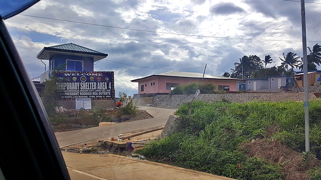
We were fortunate to have been shown around the little dwellings - some occupied, some not yet.
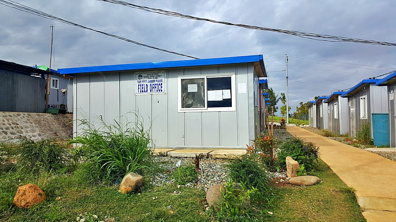


The doors are made of plastic - the ones some people use as their bathroom doors. The walls - which I think are GI sheets (coated with something), do have a 'sandwiched' insulating material about 3 to 4 inches thick. So it's probably not scaldingly hot at midday, and probably not too chillingly cold at night.
By the way, did you know that Lanao Lake is also a summer capital? While it may not be a well-known cold place (because of the rebels, probably), Marawi is actually 710 meters above sea level. Baguio is at 853m, Malaybalay is 828m, and Tagaytay is even only 634m above sea level. Aba, malamig din dito!
Hopefully those temporary shelters are warm enough at night!
We roamed around nearby areas, and I saw that some houses also being built are made of concrete.

Ah, no time to ask. We were 'encouraged' to just stay in the car as we roamed, and 'discouraged' from walking around as we might stir the community to thinking we were another donor about to distribute something they could use. That happened to us somewhere north of Tacloban - not easy to get out of!
Whatever... I just assumed those are a fortunate (or favored?) few! Hmm, whatever!
Then we saw a "temporary elementary school"...


We were happy na, just joyriding around, to see what we could see up close and personal! We thought, this was actually even better, than our failed plan to roam inside the "war zone" with nothing but ruins!
Some clusters have differently-colored houses, probably depending on the contractors? Probably.

Some such little houses are "extending" or making concrete fences at front or back of their units!

Some of them could still afford to build concrete fences around their temporary shelters. Oo nga 'no?!
This was a nice exposure to other realities in life. We couldn't help but compare them to majority of the Yolanda victims. Malayo! Not all, but most Yolanda victims were already "victims" in some way, as they were/are from a marginalized sector, living on shanties along the shorelines. Not all but majority.
These folks in Marawi had homes, buildings or businesses in the city's economic center but ruined by the war. Yep, some of them could still afford to purchase a few hollowblocks and cement nga naman!
As groups of victims, they are actually not properly comparable. Very different, very case-to-case. Oh well, sometimes (paminsan-minsan lang), your dear PT (yes, that's me), also likes thinking with others such as my companions on this Marawi trip, about very complex things. Makabuak og agtang usahay!
Anyway, joyride pa more!
I saw this 'new development' and a companion said it's an additional transitional housing area. Woah!

And more houses, we noticed, were mostly on uneven terrain that may be flood-prone in some parts.


After the shelters, going downtown, we passed by this place and I asked "is that still the capitol"?

Nobody answered, driver instead made an abrupt stop and turned sharply to enter that gate! Whoah!

There are so many writings, you will need to look at the topmost roof, to see that this is the capitol!

Because down below, by the curbside, this is all that you see - a very long name (then what?)!

Beside it is Capitol Mosque (Capitol Masjid). Yes, a mosque, a masjid inside the capitol compound.

We were on our way to Brgy. Moriatao-Luksadatu to see a friend who lives there. Only to learn he was not at home but at MSU as he had a class (he teaches in gradschool). Arrgh, we should've txtd earlier!
Ah, since we passed by the brgy. hall (yun ang napagdeskitahan bisitahin), we dropped by to say hi!

And I must say, I learned a lot from that short but meaningful conversation - like the feelings of people in her barangay when gunfire was being exchanged, with their abodes seemingly in between opposing camps. "Should I run? Where to? Won't one side mistake me for the other? How would I know and how would they know? Should we stay hiding? Where? Won't those big explosions penetrate where I hide"?
Those were just few of what the people were thinking. Add to those your responsibility as an officer of the barangay. "Should I go out and announce things? What will I say? How sure am I about those that I will say? Do I even have a megaphone? Won't I get shot if I step out? Are barangay captains or tanods exempted from gunshots? Who said? How would they know its just me? Am I not one of their targets?
I was dumbfoundedly struck when she said "the thing that happened here, is not something that local governments discuss or prepare for with drills and equipment, such as typhoons or earthquakes". Da!
There were many more questions, and we wanted to hear more, but we were out of time. Arrgh!
The dear motherly barangay captain had many more things to share (I was sure of that), like she even touched a bit on the issue of Maranaws being mostly merchants, that they may have been out during the siege, but they own or rent properties at Ground Zero, so they also deserve relocation assistance.
A very enlightening conversation. Buti na lang i resolved na "tuloy ang biyaheng Marawi"!
During our conversations, there was also a mention of a nearby Buadi Sakayo Mosque, where the war ruins could be seen from. Driver said it's a street name therefore easy to find, so we went to look for it.

Here here... I tried doing something with the photo so we could read what the arch says...

Hey, I found something interesting that got all of us searching on google! The street name hahaha!

That's what we frantically searched on google for. What does Buadi mean and who was Datu Buadi Sa Kayo? If Amai Pakpak was born in Buadi Sa Kayo, that therefore means Datu Buadi Sa Kayo became a name of a place. What is it now? Barangay Bangon? The length of Buadi Sa Kayo Street? Ah ang hirap!
But we were walking, and we already reached the mosque without knowing Buadi Sa kayo! But wow!

I hope those in-charge of that mosque could/would do something to save it. Many parts are decayed, obviously won't last a few more years if left unattended. It has a simple yet attractive moorish design.
Oh, we could not see Ground Zero from the mosque grounds (which was our main purpose in coming here) unless probably if we climbed up the minaret, which obviously won't be possible. Is it even safe?
So we moved further down the road (Lower Buadi Sa Kayo St.), towards the water's edge...

Trees on that peninsular hedge (foreground) cover the rest of the areas at left (nearer Agus Bridge 3)

Okay, we needed to go back uptown -MSU Campus to be exact- to meet with our professor-friend, just to say hi-and-goodbye, really! Also an opportunity to say the same hi-and-byebye to Lt. Reliable Source (remember him?) who was incidentally also on campus that time, for some official function whatever!
On the way, we happened by this house in the 'safe zone', not Ground Zero, but mukhang binomba rin!

We also passed by this famous landmark, which our driver said to me "this is not yet in your blog"!

Anyway, what intrigues my driver, that in turn now titillates me, is that declaration at the bottom of the KM 0 mark. It says "original reference point of all roads in Mindanao". Why, When, and Who said so? I am now intrigued too! If we get to know the answers to those 3 questions, we would best understand how our forebears traveled and measured their travels in the past. Interesting! Research pa more. Da!
Then we arrived at Mindanao State University's Marawi Main Campus. I was happy!

Last I was here was high school pa ako (don't do the math) for some three-day contest whatever!

But even in the car, I saw things that had my eyes open wide in surprise! Like the Commercial Center!

Ah, I am not joking. I know there are university campuses with commercial centers/areas. The easiest examples I can think of are UP Diliman's Shopping Center and/or UPLB's sosyalin commercial areas. I know there are others like DLSU, Ateneo, UB, UV, UC, USA, etc.., but theirs are generally smaller stores (some have malls) yet mostly owned by the university management or their employees' associations.
In MSU, there are coffee shops, restaurants, tarpaulin printers, etc. Okay fine, look at the photo above, it is an ukay-ukay where obviously the employees and/or owners also live in the same space they use commercially! Idagdag mo na ang sidewalk vendors, barkers, tindahan ng kutson, wet and dry market with tindahan ng karne, isda gulay, prutas abubot, fake shoes, phones or watches, everything on earth!
I did think... bakit eh kailangan naman lahat yan ng students ah? Oo nga.
But it looks like ganito: dalhin mo ang Fairview Market, Manggahan, isama mo na ang Susano Market doon sa loob ng UP Diliman Shopping Center. Ganun! You can't say they're outside, since they're more than a kilometer inside after you enter the gate! And all kinds of public transpo await beside the gym!

Or i-declare mo buong Quiapo as part of MLQU Campus. Parang ganun hahaha!
Well, I guess MSU can do that (a mala-Quiapo community inside campus) because they have such a wide land area. But I think I saw a building that has a concrete fence around it. Hmmn, security issue?
Anyway, I was happy I saw even just the outside of this building, The Aga Khan Museum - since 1963!

We were heading out of Marawi to Iligan, for me to check-in at my hotel, and for my companions to go home to CDO. Let me tell you, this evening trip (Marawi to Iligan) took almost three hours. Why was it so? Because of the many checkpoints, and night-driving under heavy rains. I was still happy anyway!
Along the way, companions asked what I thought of our trip. I said it was still a fantastic educational joyride, even if we were not allowed to Ground Zero - which was probably even a blessing in disguise.
Oh aw, my reply surprised my companions when they asked me "what do you think of Marawi now"? I said Marawi is the billboard and tarpaulin capital of the world! They're just so annoyingly everywhere!
Hahaha, let's roam Iligan tomorrow. I am almost sure the tarpaulin thing will prevail, even there!


Comments
Post a Comment