Taipei To Cebu To Tacloban
This was one time I wished my flight would be delayed heheh! Well sorry me, it was departing not just on time, but even ahead of its published schedule (I suspected)! How'd I know that? Oh just guessing!
At 0932H there it was about to dock at the gate. So I surmised, the airline's manager at Taoyuan would want to dispatch that plane at 1032H because the usual 'parking fee' that they pay is only for an hour!

Look, at 10:09AM, the forward section of the aircraft belly was done loading. Nagkukwentuhan na sila!

Kaya ayan, madalas naghuhuntahan na lang ang mga gi-ahak sa front area hehe, while waiting for the rear section folks to finish loading. I think there is not so much cargo (yet) from TPE to CEB on AirAsia.
But if there is cargo and they are heavy, those would be loaded first sa pinakaloob ng airplane via the rear door, followed by pinakaloob din ng plane using the front door - so that our checked-in baggage are all near the door, para pagdating, unang maibababa and we don't wait long at baggage claim area.
Yes, imagine that, even the belly part of a plane uses science! Maybe we should talk about it soon!
Hmm, 1024H this was attached to our plane. Many folks call it GPS, but I guess it's an ASU - a "starter"!

So, back to that photo above. Ganyan ba paandarin ang plane? Well yes and no hehehe! First let's talk about GPU and ASU. GPU is Ground Power Unit. It is [sometimes] used to provide power to your plane (while not flying, obviously). Generator kumbaga - and it looks something like that thing in the photo.
ASU means Air Start Unit. It's used [obviously] to start the engines running. And to us passengers who are non-technical people, it also looks something like the above photo! Minsan mas maliit pa dyan na natutulak/nahahatak ng tao, minsan itinutulak ng sasakyan, at minsan ganyan sa picture - nasa truck!
They look almost the same, that's why many people refer to any or both as just "GPU" or even "GPS"!
So ganun nga ba magka-power ang edroplano? I said "yes and no". Yes if the plane by itself cannot do its normal functions on its own engines due to some technical handicap. Hindi lagi ibig sabihin sira si airplane ha? Example: bawal magpa-andar ng engine sa gate dahil sa ingay o nagtitipid lang si airline.
It is more costly to have the airplane's engine running while on-ground, than just use a GPU (that may even be owned by the airline or rented from the ground handling company). Tipid-tipid pag may time!
Now there's something that the ASU has, that the GPU doesn't - compressed air used to actually blast start the engines. Di tulad noong unang panahon na iniikot lang yung elesi para umandar si airplane!
AND ang latest maritess: there are newer equipment, that already combine GPU and ASU in one truck! Those are called Ground Power Systems by the airline industry. That's why we now keep hearing GPS!
Now, if it's not a 'combi', I'll say the above is an ASU for 2 reasons: 1) there's an extra hose (for blasting compressed air to start engines?), and 2) ikinabit yan 5mins before departure lang - para umandar na!
Anyway and okay... back to my departure flight... and at 10:31AM pushback na, instead of 11AM!

Because I was on the right side of the plane (seat 1F), I could see Gates A8 (left edge of photo) and A9 (right edge) - and that is the edge of Terminal 1, after which there is Gate D1 of Terminal 2, remember?
I know some of you will be curious as to what those boxes are, right? Let me tell you something about those. They were unique to Taiwan but now being used worldwide since Taoyuan International Airport Services (TIAS) do not only make/use them here, they also sell those to airlines and ground handlers!
Ano nga yan? Ah eh.., iba-iba ang tawag dyan, depende sa lugar. As a product, that is a "Non-powered Aluminum Cabinet Luggage Trailer". O ano, magtatanong ka pa? Hahaha! Sa atin, those are 'pushcarts'.
Those are the equivalent of [this] that we talked-about sometime ago. In their version, each pushcart has a 'housing' or 'cabinet', so that, luggage or even cargoes are safe from the elements. Better, right?
Actually, if you look at the picture again, there are bigger ones, and they're a little different. Those are called "Non-powered Aluminum Pallet Truck Trailers". Those are for 'pallets' - big sheets of metal that look like humungous cookie sheets - but in Taoyuan's case also covered kasi sila ang gumagawa nyan.
Anyway, taxi time. Our plane taxied from Gate A7 to a far Runway 05R takeoff. That's about 4kms away!

Another exciting part for me on this departure was that, the big airplane I was riding on, would have a chance to pass over the highway again. Why was it exciting? Ah wala lang. Wala kasi ganyan sa atin eh!

After passing over the highway, we still had to turn right, then another left. Ayun pa rin si Novotel o!

Okay, so takeoff position, goodbye Taiwan na talaga for now. Let's go kapitan! Abante! Lupad! Togdon!

Hmm, "very rare", so trivia nga! Okay sige na, but do you know what it is? It's not a pedestrian crossing ha?! Hindi rin dyan nag-shooting ang The Beatles in their most famous picture (and album cover btw)!
That is called a Runway Threshold - kung saan 'officially', 'technically' and 'professionally' nagsisimula at nagtatapos ang isang runway. Runway ng airplane at hindi yung rampahan ng mga model ng damit!
For departures just like what we were about to do, that's where an aircraft can/should start its takeoff roll. For arrivals, no plane can/should land before that zebra line (unless in an emergency, jusko wag)!
In other words, any normal takeoff or landing must be inside the zebra lines.
Ah, eto ang trivia: did you know that the length of a runway is measured from zebra line of one end to the zebra line of the other end - only? Yup, only the 'usable' space for landing or takeoff is measured.
Eh, yun lang naman pala ang kailangan, bakit madalas me sobrang runway outside of the zebra lines? Aw yun? Kailangan yun! There is what they call a RESA or Runway End Safety Area. Yan yung additional pavement labas ng zebra lines, that are used in cases of emergency or problema sa eroplano. Ganern!
Oh yes, kasama na dyan ang namali ng tantya si kapitan - juskolord! Pwede rin "wind shear effect" na parang biglang nawawalan ng hangin sa lugar at nalalaglag si airplane ng wala pa sa threshold. It can also be masyado pala mabigat si airplane (dahil OMG mali ang weight & balance computation) - kung kaya kelangan pa ni kapitan ng extra lupa para umarangkada to takeoff. And many more emergencies!
Kaya huwag mo nang pag-deskitahan iyang extra semento sa dulo. In fact, after the RESA, meron pang "required" na extra unpaved lupa. It's called a "clearway" - para bumagal si plane pag nag-overshoot!

And we took off! Only 1055H and we were already mid-air. Actual takeoff must have been about 1052H.

Only about 15 minutes after takeoff, meals were sold, and pre-ordered meals (like mine) were served.

I was more interested in looking out the window and see the places we were flying by. But, now that I had to attend to 'food', I must have missed some of the nice aerial views of New Taipei and/or Taipei.
It was a cloudy sky though, so I said "there's always a next time"!
I found it cute that our 'flight path' stayed on the Pacific side of Taiwan, not mainland side hehehe!

That known, I observed what we were passing by. Trip lang, since I never did this in my younger years. As in I didn't at all really care about the wonders of the outside views from an airplane, in those days.
And good that I was on the right-side window (Seat 1F). My first interesting sight, this city and runway:

By the way, in case you're curious, it's a small domestic airport, with a runway of just about 2km long, probably comparable to BCD (Bacolod). But it is a big city, the biggest on Taiwan's east coast, actually.
It is one of the good tourist destinations in Taiwan, especially summer where there are festivals (e.g., hot air balloon!). When I was young, I also saw many tourists going to some island or islands nearby.
About 40 minutes after takeoff, we were already past the southern edge of mainland Taiwan. Hmm, it would have meant we were already entering Philippine territory. Wow, that quick! What island is that?

I saw a big ship cruising-by, probably on it's way to pass by the hotly-disputed West Philippine Sea.

Just about 15 minutes more and I saw that we were already passing above Laoag City. Yehey!


If you're familiar with Ilocos Norte, you should be able to see that the entirety of Laoag City is in that photo! Actually, even the towns of Sarrat, San Nicolas, Batac, Currimao and Paoay are in the view too.
In fact, the white arrow points to Paoay Lake, and the green arrow points to the Paoay Sand Dunes, at the left end of which is Culili Point, that's why some folks refer to the area as Culili Point Sand Dunes.
I missed Badoc Island still in Ilocos Norte. But further south, here's Poro Island in Cabugao, Ilocos Sur.

Hmm, I realize just now, I haven't been to a beach for a long time now - maybe already a month.
Ay, as if to stop me from thinking just "beach", a minute after, we were already over the big Abra River!

On foreground of the picture is a big part of Abra province. I could see Tayum and La Paz. Above them is the capital Bangued - hello to family and friends 'down there' in Abra who I have not seen for ages!
Hey I find it cute that my "hello" says "down there in Abra", because we usually say "up there", "up to" or "up in" (the mountains) of Abra. But this time, I was passing-by up in the sky, so I say "down there"!
This is part of Lagben River (to the left is south and to the right is north) since we were flying to Cebu.

The funny part... some clouds got in the way of my views, when they were gone, I lost where we were!

Hah, the (visible) rivers big or small, were/are my only hope of getting to identify a place. But 'no can do'! It is not often that I pass this way by air. I just knew we were flying southward from the Abra area.
Anyway, next I saw this river that's already on the plains just out of the mountains. Hmm... San Jose?

Especially that after about 5 minutes, we were already looking down at Laguna Lake! Can you see it?
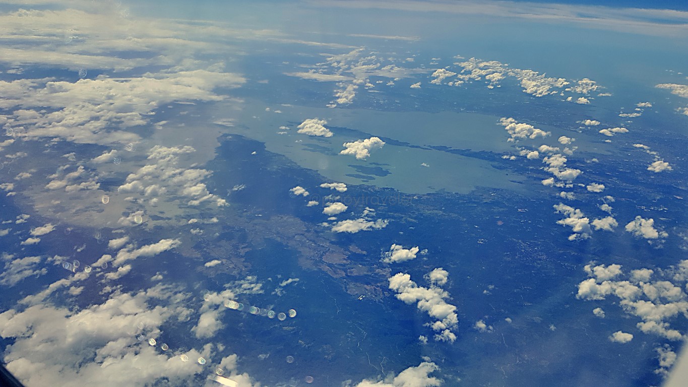
After 35 minutes from the above-picture of Laguna Lake, I could not identify these little islands. Argh!


The next scene I saw, is something I am very sure of - the cement mines of Naga City, Cebu.


By the way, since we're in this topic already, I do wonder, for how long (I mean until when) could that cement digging process be on that site? Does the thing (whatever it is they're getting from earth) not ever get depleted? Na-a diay forever? Apo cement have been at it since 1921! Doesn't that ruin earth?
I'm sure I'm not the first to ask, but what I'm sure-of is, I do not hear much negative news about them - local, national or international. Therefore, the extraction (of whatever it is) is safe both for mankind and mother nature? Oist, sa totoo lang, I didn't actually know that cement pala is mined (hinuhukay)!
It was not until I have been frequently flying, that I kept seeing those huge pits, and when I would ask around, everyone tells me that is Apo Cement. Akala ko, ang semento eh tinitibag na rocks or bundok!
So ano pa nga ba... we landad at Mactan-Cebu International Airport about 2.5 hours after takeoff!


Another good thing, we landed in Cebu about 1:20PM when it should have been be 1410H. No hurry, I did not have to rush to transfer between T2 and T1 as I was transiting to a 4:30PM flight to Tacloban!
In fact, I walked from arrival area of T2 to departure area of T1. Eh hindi naman umuulan. So chill lang!

Ah, I even stood for a moment to take this picture of the very short distance between the 2 terminals.

Anyway, you already know the drill, right? I breezed thru check-in, went to Mabuhay Lounge, and...


And then my PAL flight PR2238 was over Camotes Islands again. Oh the white sand beaches!


Then clouds 'killjoyingly' deprived me of wonderful views to the places below. I think that's Ormoc.

After a mere 21 minutes, here we were by Manlurip Road in Pawing, approaching TAC Runway 36! Yey!

So that ends my Taiwan trip. Let's go to a beach next! Miss ko na ang dagat at dalampasigan!
11 12 13 14 15 16 17 18 19 20


Comments
Post a Comment