Kalanggaman Sceneries and Memories
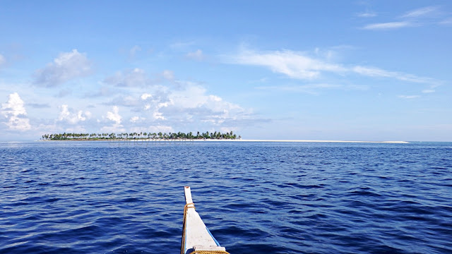
This was my view as we approached the island. Of course the whole boatload of all of us were excited! Almost a commotion as everyone tried to take shots of the whole island! And this is one reason I tried my best (schemed actually) to be seated front of the boat!
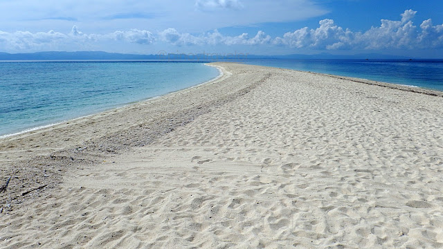
Teka, for those not in the know, my picture above (low-res of course so that no one starts using it for their own commercial purposes), is not off-center. Look closely from middle of the picture to the right edge. That is the white sandbar Kalanggaman is famous for.
Here was our (video) approach to the island:
Okay, so I arrived!
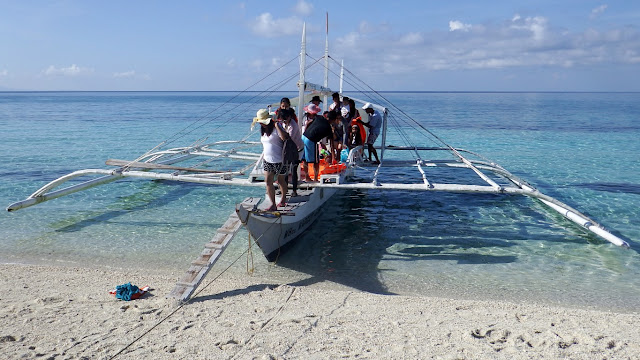
I took a picture of our boat while the last passengers were still disembarking...Look at the sand, not that fine, right?! Dito lang yan, but on other parts, its gorgeous!
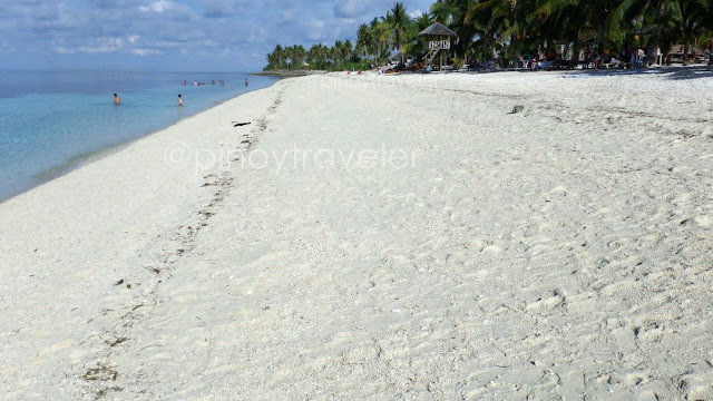
And then I looked to the left (west side)... ah well, breathtaking enough, right?To the right (east), meaning behind this camera position, is the famous sandbar, but I did not take a pic (yet) as camera would face the sun. We'll get there later. 'Wag kang atat!
So, I arrived at the island, and I immediately started to roam the perimeter. But of course, I started at center where our boat just docked! This is the southern portion of the island. If you trace on a map, this area faces Camotes Islands way veeery faaar down south.
Their still unfinished marker or whatever its called (alangan namang epitaph hehehe)!But I see a hint that this is one good work of art ha?! The dolphin looks cute enough!
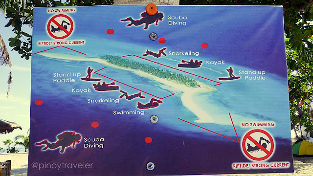
Good that the authorities posted this map that serves both as guide and warning...I wondered what the red dots mean. Well, important to note are the no swimming areas. Yung apat na hindi red dot sa gitna, 'wag nyo na pag-deskitahan. Tansan ng softdrinks ang mga yan. Pampadikit nung tarp to the coconut tree trunk. Kayo talaga, you are so!
Here's another warning - memo type naman, just in case you can't understand drawings!This is before you go out to the sandbar - the background image of that tarp actually!
Okay, enough of the center of the island. This is where "civilization" usually hub anyway, so you must have already seen many pictures of this area on the web - the store, the huts, the swimming area, the people in charge and so on. Let's go elsewhere uncommon!
For easy reference, let me again pull up that map above. This time I placed numbers...You of course recognize that area in #1. Yep, that is where my boat arrived, and that is the "center" of the island I was talking about - where the store is, where all the bustle is, and where most everyone swim and have fun. All the way to #4 or beyond, this is the southern beach strip. Where most of the fun happens. Where you go to see and be seen!
But I had an "important" itinerary. I also planned for this. I needed to go north (#2). So...
North Kalanggaman
I walked northwards (as if malayo yun, eh a few steps lang naman hehe). The other side of Kalanggaman Island (#2), if we might call it that. Probably not even a hundred meters away from the dock (#1). I needed to verify and confirm something to my royal self.
Eto na... when I reached this place, I was exclaiming loudly to my self (walang tao eh)..."Sh*t this is the place! Tang*na sabi ko na nga ba I have been here before! Oh sh*t hehe!
More than a decade ago... when the "in" phone brand and model was Nokia 3210... and when most everyone in Makati still had 'Beeper 150' or '141 Get the Message Easycall' hahaha, I went vacationing with a friend to the beautiful little town of Bogo in Cebu.
We had fun visiting the fishermen and their families that make dried fish (bulad, danggit, etc). In the course of our little "tour", a fisherman bragged about this "white island" that is about an hour away on his boat. Long story short, early the following day, we set out to that "white island" with his son and wife who brought rice, fruits and other eatables.
That "white island" is now actually this! Kalanggaman Island!
What do I remember? The "bato-bato" beach but all were smooth, "dili hait" (not sharp), where we could walk barefoot though at some areas slippery. And the low but long stretches of inverted stair-like formation (baliktad na hagdan-hagdan). On top of that, I could still remember the area where we met other fishermen known to them, who were resting in the area, while their nets (pokot?) were already cast just a few meters away from this beach. We even tried "stone-stacking" here during that time!
Having satisfied my curiosity, and having confirmed that I have really been here long ago, some nostalgia settled-in hehe. I got a sense of my bearings. If I was standing on that rocky/stony area (#2) facing the water, then, we must have arrived on this island at its edge to my left (#5). So, I started walking to that area passing by the shoreline.
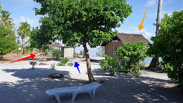
That 'nostalgic walk' only lasted until that area I marked "#3" on the map above, because interesting "new" things distracted me (more on invited my attention, actually)! Like this:There are now a scattering of structures on both sides (north and south), even away from the central area (#1). On this pic, I was standing in the middle of the island, facing west.
The red arrow points to a nice cottage. It just looks unattractive because of that raggedy old golden canvass they propped at the entrance/foyer to block harsh direct sunlight. Its nearest water's edge is to the right, where I came walking from (#3). But no one would stop you from running to the left side, right? That's #4 on the map! Do you notice that white block towards the back of that cottage? That is its own concrete comfort room!
The orange-colored arrow at left edge of photo above points to a big wide cozy cottage for day trippers (#4 on map). The cute 'gig' here is there are small tents around it. Oh ha?! Maybe families camping overnight, but they dine or party together at that big cottage!
The blue arrow points to another, similar open-deck cottage for day-trippers. But the cute event here was a cuddly little boy of probably 2 or 3 romping around hubo't hubad!
I walked onwards westwards still at #3 and saw this...Orange arrow points to a hut that looks like it can be rented too. Though I would not wish to be in there, even for free, on a windy day. If you didn't get that, try imagining where the orange arrow comes from! Lubi bai lubi! Just one "lubi" and you're... simba ko!
Red arrow points to another one of those big open airy cottages good for big families and groups. But this one is on the north side (#3). The sea views here are more placid.
Ah, the blue arrow points to something interesting. See below!
This one is quite a "construction of note"! See the bottoms of soda bottles on the wall?Those are the 2 liter plastic bottles, filled with sand, and used whole like hollow blocks. Well, they made the bottoms stick out a bit to provide some aesthetic value!
They are constructing a number of public toilets like this, all over the island. I entered this one just to check it out, and well, no running water, just a "timba and tabo" of sea water. No fresh water is understandable as this is just a tiny island far from any fresh water source. Sea water is enough for these toilets. But, if not constantly cleaned... ayay!
This is that open-deck cottage at #3, that the red arrow above points to...Simple but cozy gathering or dining area, right?! For big groups, I mean. Not for me :) !
Back to the middle of the island (between #3 and #4), I saw this...They're making a wider pathway from east to west, I wondered, what for. They're even decorating the sides with cut coconut tree trunks. This is wide enough for 4-wheeled vehicles to pass. But I don't think their putting such vehicles out here. This is such a small island, I think only about a kilometer long. So, maybe a road for ceremonies ek-ek!
To the left of that path (#4) as I go westwards is this...Because there are also rocks and stones on this part of the beach, people are not keen on staying at this place, which makes it all too serene. And the sand here is a merry mix!
On some parts, the sand could be a bit coarse, almost like gravel...
But on other parts, just steps away, the sand could be very fine and nice to trod on...
Moving-on further westward, if you still remember our "reference map" above?
I was walking on the widened middle path between #4 and #5 when I saw this...Hmm, a chapel? That man seemed to be praying so I slowed down until he was done.
I looked intently at that man as he prayed (kinilatis ba)! He looked like the patriarch of the 'yayamanin group' that took off on the first boat! They all had 2 or 3-letter surnames, I saw that on the manifest, remember?! The naughty me thought: holdapin ko kaya ito?!
But I am wiser now. I knew, walang dalang kayamanan yan. Singkit eh (oops singkit din pala ako hahaha), nasa misis ang wallet nyan! Besides, saan ako tatakbo after the holdap eh wala naman akong "espid boot" or "polopokter"! Hehe 'wag nyo akong tularan ha?!
Mag-isip ba ng masama eh, sa harap pa ng chapel?! I am sooo! 'Wag tularan, children!
Okay, the man going away, I approached the chapel... ayun sya paalis na o!Aba, nice tiny little chapel. Bare and simple, but surrounded by a wide flat 'nothingness'. Pwede beach wedding! Di ba Sir EventsMaster?! Kaso, aandar nanaman ang mga "rules of the church" na kesyo sa simbahan, kesyo sa parish ek ek! Na lahat naman debatable!
Here's a closer look... Nag-dasal ako dyan, promise! I even kneeled on that pew!Not sure if there is supposed to be some symbolism that the builder of this little chapel wanted to show. It has 5 posts, the roof is pentagonal, and the floor is like a reflection of the roof's polygonal shape. Hmm, di ba pentagon or pentagram or the number 5 is not a good symbol in the catholic faith? I just read about it somewhere, so am not sure hehe!
The most wonderful thing about this little chapel is the serenity of the place. Not many people come this way so all you hear are the leaves swaying in the wind, or the little waves lapping at the sand. Good for saying prayers, meditation, or just a little "me time"!
Alright, I moved on! Refer back to our "reference map" above, if you must.
Walking to the west end of the island, that's #5 on our map, I stumbled upon this..!Again, this is the island's western edge. Few people, or none at all, ever come this way! And as if custom-built for me, myself and I, there is that tiny hut good for, just me, okay?!
There is even no table. Just three planks that serve as benches on three sides of the hut. Of course, the 4th side is left without a bench/plank so it serves as "entrance"! That is my backpack that seems to be happily leaning on one of the posts! Nakiki-"lone-time" din!
And the nostalgia continues...:
Sitting here, with no noises around, I immediately recognized, this was where we arrived at, on our boat ride from Bogo. We settled under one of the big trees (behind camera).
I also recall, there was a sandbar somewhere out there, behind that tree on the right. From this picture, we can even still sense a hint of that sandbar, right? Yes, I remember, because our boat was docked down there. And that is, almost 2 decades ago, imagine?!
This place is where I spent most of my morning in Kalanggaman. Muni-muni lang...Marveling at how good the clouds were reflected by the sea. From time to time tinkering with the camera for panorama shots like this! Just savoring the Kalanggaman morning!
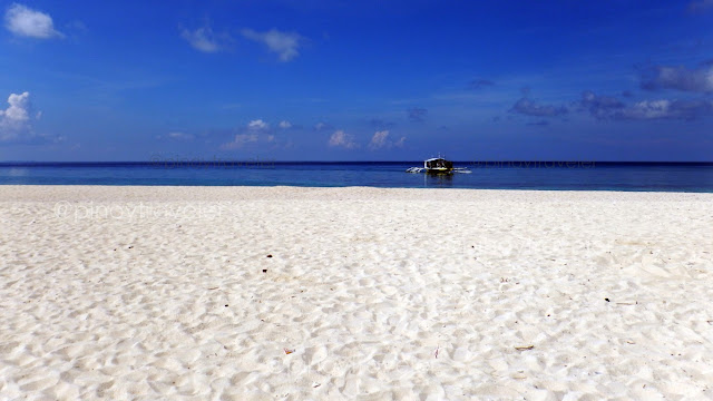
The incredible beauty of this island is...Where there are no rocks nor stones, its the pristine fine white sand that is all around!
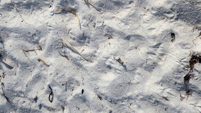
And the beauty at this western end of Kalanggaman is...Few feet ever trod on this shore. Yang mga footprints na yan? Almost all are mine. Lang!
And at this end of the island... it is not a monotonous glaring white that you see...There is real life. There are a number of living things, flora and fauna. You can even hear more birds a chirping up the trees in this area - there are none over at the central area, or their melodic sounds are probably just drowned by the din of shrieking humanity!
It is on this side of Kalanggaman island that I spent the best part of my morning. I would have lasted until end of day here doing absolutely nothing, other than just daydream!
But I had a very strict 'mental schedule' to follow, which, as it was, was already delayed by about an hour, because I wasn't allowed on the first boat at 6AM, because I was not allowed to reserve, because I was not part of a yayamanin group na 2 or 3-letters ang apelyido! Because... ah, ang daming because! But I know how to manage my time well!
I arrived at this island at 7:37AM, I reached my "tunganga area" (#5) at 8:06AM. When I looked at the time again, it was already 9:02AM. Time to move to the east side - so I could take some pictures at the "famous" sandbar and take a boat to mainland Palompon at 10AM, so I could still catch a 12NN VHire to Tacloban, for a 4PM social obligation!
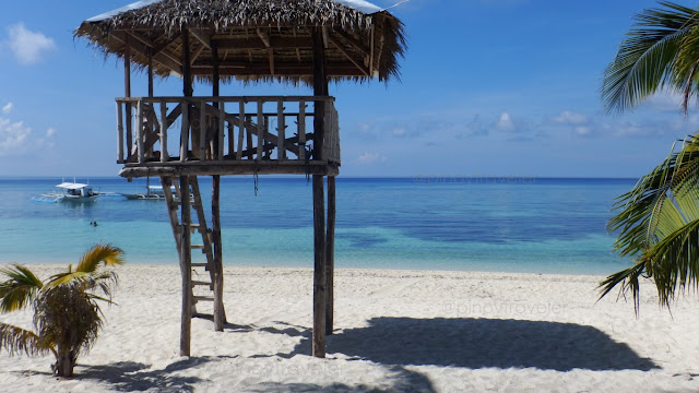
Still remember our 'reference map' above? I walked from #5 to #6 passing by here #1I needed to show you this view of the life-guard tower at the central area (#1), because it is only here that there's such a thing. Which should give you a hint, right?! Swim or frolic in the waters HERE ONLY, for your own safety! At other areas, no life-guards. Sige kayo!
My take is, as long as you are in front of trees, boats and cottages, its still okay to swim,Otherwise, be very afraid. The rip current at the sandbar areas are VERY dangerous. Why am I saying this? Because I tried it, with supervision of a life guard and some boatmen.
So, don't swim at the sandbar areas (you will be apprehended if seen anyway). But what if not, since life guards are only at #1? Then you may become part of the "statistics"!
Another hint: note where the boats are "parked". It will be safer to swim or magtampisaw there. Why? Because, them boats also get to be dragged by the rip currents, so they dock or drop anchor at safer places - usually the central area nga at #1 in our reference map!
So okay, I went forth to the end of the sandbar for my "been there, done that" photos...This was on my way there. Good it was only past 9AM. The sun's heat was still bearable.
While walking towards the end of the sandbar, I turned around to see this...That's the busy area (#1) where everything is a bustling. Had to keep looking back at that place, as I needed to estimate if I can still manage a "safe return" if it felt already so unbearably hot. Mahirap na, what if hinimatay ka sa kalagitnaan? I was alone 'no?!
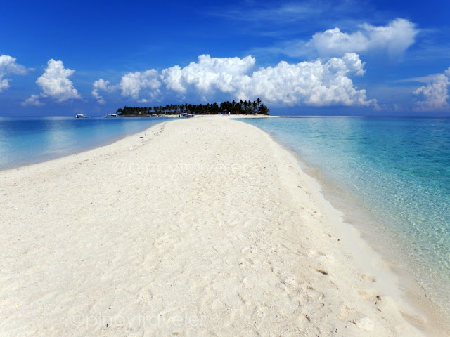
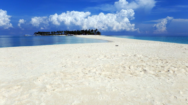
Nearing the end of the sandbar, the island's center is a nice view...Hey, I got some kind of an almost straight shape of the sandbar up to this point! What makes this exciting is that this sandbar constantly changes its shape, depending on the strength or absence of waves, wind, and of course the strong sea current!
And at the very end of the sandbar (#6 on our reference map)..,This is how the island looks! I think it is nicer and more memorable to look at the island from this end of the sandbar, 'no?! Than take a picture of the sandbar from over there.
From same position as above, I took this 360 degree pan, and here's how it looks
Kwento: Did you notice my photos and video of/at the sandbar above do not show any people? Ha, even I was surprised! Maybe all those groups were still eating hehe! But I noticed that many of them started flocking this way, after me. Maybe all those folks were hesitant coming to the end of this long sandbar without the presence of other people.
Why did they come only after me? Maybe they thought I was their guardian angel!
Hahaha, okay, this has been such a long story. Let's go home!
==========================================
Click these numbers for a chronology of my notes:
01
02
03
04
05
06
07
08
09
10
11 12 13 14 15 Fifteen stories!
==========================================
Or just click "Newer Post" or "Older Post" below.
Teka, for those not in the know, my picture above (low-res of course so that no one starts using it for their own commercial purposes), is not off-center. Look closely from middle of the picture to the right edge. That is the white sandbar Kalanggaman is famous for.
Here was our (video) approach to the island:
Okay, so I arrived!
I took a picture of our boat while the last passengers were still disembarking...Look at the sand, not that fine, right?! Dito lang yan, but on other parts, its gorgeous!
And then I looked to the left (west side)... ah well, breathtaking enough, right?To the right (east), meaning behind this camera position, is the famous sandbar, but I did not take a pic (yet) as camera would face the sun. We'll get there later. 'Wag kang atat!
So, I arrived at the island, and I immediately started to roam the perimeter. But of course, I started at center where our boat just docked! This is the southern portion of the island. If you trace on a map, this area faces Camotes Islands way veeery faaar down south.
Their still unfinished marker or whatever its called (alangan namang epitaph hehehe)!But I see a hint that this is one good work of art ha?! The dolphin looks cute enough!
Good that the authorities posted this map that serves both as guide and warning...I wondered what the red dots mean. Well, important to note are the no swimming areas. Yung apat na hindi red dot sa gitna, 'wag nyo na pag-deskitahan. Tansan ng softdrinks ang mga yan. Pampadikit nung tarp to the coconut tree trunk. Kayo talaga, you are so!
Here's another warning - memo type naman, just in case you can't understand drawings!This is before you go out to the sandbar - the background image of that tarp actually!
Okay, enough of the center of the island. This is where "civilization" usually hub anyway, so you must have already seen many pictures of this area on the web - the store, the huts, the swimming area, the people in charge and so on. Let's go elsewhere uncommon!
For easy reference, let me again pull up that map above. This time I placed numbers...You of course recognize that area in #1. Yep, that is where my boat arrived, and that is the "center" of the island I was talking about - where the store is, where all the bustle is, and where most everyone swim and have fun. All the way to #4 or beyond, this is the southern beach strip. Where most of the fun happens. Where you go to see and be seen!
But I had an "important" itinerary. I also planned for this. I needed to go north (#2). So...
North Kalanggaman
I walked northwards (as if malayo yun, eh a few steps lang naman hehe). The other side of Kalanggaman Island (#2), if we might call it that. Probably not even a hundred meters away from the dock (#1). I needed to verify and confirm something to my royal self.
Eto na... when I reached this place, I was exclaiming loudly to my self (walang tao eh)..."Sh*t this is the place! Tang*na sabi ko na nga ba I have been here before! Oh sh*t hehe!
More than a decade ago... when the "in" phone brand and model was Nokia 3210... and when most everyone in Makati still had 'Beeper 150' or '141 Get the Message Easycall' hahaha, I went vacationing with a friend to the beautiful little town of Bogo in Cebu.
We had fun visiting the fishermen and their families that make dried fish (bulad, danggit, etc). In the course of our little "tour", a fisherman bragged about this "white island" that is about an hour away on his boat. Long story short, early the following day, we set out to that "white island" with his son and wife who brought rice, fruits and other eatables.
That "white island" is now actually this! Kalanggaman Island!
What do I remember? The "bato-bato" beach but all were smooth, "dili hait" (not sharp), where we could walk barefoot though at some areas slippery. And the low but long stretches of inverted stair-like formation (baliktad na hagdan-hagdan). On top of that, I could still remember the area where we met other fishermen known to them, who were resting in the area, while their nets (pokot?) were already cast just a few meters away from this beach. We even tried "stone-stacking" here during that time!
Having satisfied my curiosity, and having confirmed that I have really been here long ago, some nostalgia settled-in hehe. I got a sense of my bearings. If I was standing on that rocky/stony area (#2) facing the water, then, we must have arrived on this island at its edge to my left (#5). So, I started walking to that area passing by the shoreline.
That 'nostalgic walk' only lasted until that area I marked "#3" on the map above, because interesting "new" things distracted me (more on invited my attention, actually)! Like this:There are now a scattering of structures on both sides (north and south), even away from the central area (#1). On this pic, I was standing in the middle of the island, facing west.
The red arrow points to a nice cottage. It just looks unattractive because of that raggedy old golden canvass they propped at the entrance/foyer to block harsh direct sunlight. Its nearest water's edge is to the right, where I came walking from (#3). But no one would stop you from running to the left side, right? That's #4 on the map! Do you notice that white block towards the back of that cottage? That is its own concrete comfort room!
The orange-colored arrow at left edge of photo above points to a big wide cozy cottage for day trippers (#4 on map). The cute 'gig' here is there are small tents around it. Oh ha?! Maybe families camping overnight, but they dine or party together at that big cottage!
The blue arrow points to another, similar open-deck cottage for day-trippers. But the cute event here was a cuddly little boy of probably 2 or 3 romping around hubo't hubad!
I walked onwards westwards still at #3 and saw this...Orange arrow points to a hut that looks like it can be rented too. Though I would not wish to be in there, even for free, on a windy day. If you didn't get that, try imagining where the orange arrow comes from! Lubi bai lubi! Just one "lubi" and you're... simba ko!
Red arrow points to another one of those big open airy cottages good for big families and groups. But this one is on the north side (#3). The sea views here are more placid.
Ah, the blue arrow points to something interesting. See below!
This one is quite a "construction of note"! See the bottoms of soda bottles on the wall?Those are the 2 liter plastic bottles, filled with sand, and used whole like hollow blocks. Well, they made the bottoms stick out a bit to provide some aesthetic value!
They are constructing a number of public toilets like this, all over the island. I entered this one just to check it out, and well, no running water, just a "timba and tabo" of sea water. No fresh water is understandable as this is just a tiny island far from any fresh water source. Sea water is enough for these toilets. But, if not constantly cleaned... ayay!
This is that open-deck cottage at #3, that the red arrow above points to...Simple but cozy gathering or dining area, right?! For big groups, I mean. Not for me :) !
Back to the middle of the island (between #3 and #4), I saw this...They're making a wider pathway from east to west, I wondered, what for. They're even decorating the sides with cut coconut tree trunks. This is wide enough for 4-wheeled vehicles to pass. But I don't think their putting such vehicles out here. This is such a small island, I think only about a kilometer long. So, maybe a road for ceremonies ek-ek!
To the left of that path (#4) as I go westwards is this...Because there are also rocks and stones on this part of the beach, people are not keen on staying at this place, which makes it all too serene. And the sand here is a merry mix!
On some parts, the sand could be a bit coarse, almost like gravel...
But on other parts, just steps away, the sand could be very fine and nice to trod on...
Moving-on further westward, if you still remember our "reference map" above?
I was walking on the widened middle path between #4 and #5 when I saw this...Hmm, a chapel? That man seemed to be praying so I slowed down until he was done.
I looked intently at that man as he prayed (kinilatis ba)! He looked like the patriarch of the 'yayamanin group' that took off on the first boat! They all had 2 or 3-letter surnames, I saw that on the manifest, remember?! The naughty me thought: holdapin ko kaya ito?!
But I am wiser now. I knew, walang dalang kayamanan yan. Singkit eh (oops singkit din pala ako hahaha), nasa misis ang wallet nyan! Besides, saan ako tatakbo after the holdap eh wala naman akong "espid boot" or "polopokter"! Hehe 'wag nyo akong tularan ha?!
Mag-isip ba ng masama eh, sa harap pa ng chapel?! I am sooo! 'Wag tularan, children!
Okay, the man going away, I approached the chapel... ayun sya paalis na o!Aba, nice tiny little chapel. Bare and simple, but surrounded by a wide flat 'nothingness'. Pwede beach wedding! Di ba Sir EventsMaster?! Kaso, aandar nanaman ang mga "rules of the church" na kesyo sa simbahan, kesyo sa parish ek ek! Na lahat naman debatable!
Here's a closer look... Nag-dasal ako dyan, promise! I even kneeled on that pew!Not sure if there is supposed to be some symbolism that the builder of this little chapel wanted to show. It has 5 posts, the roof is pentagonal, and the floor is like a reflection of the roof's polygonal shape. Hmm, di ba pentagon or pentagram or the number 5 is not a good symbol in the catholic faith? I just read about it somewhere, so am not sure hehe!
The most wonderful thing about this little chapel is the serenity of the place. Not many people come this way so all you hear are the leaves swaying in the wind, or the little waves lapping at the sand. Good for saying prayers, meditation, or just a little "me time"!
Alright, I moved on! Refer back to our "reference map" above, if you must.
Walking to the west end of the island, that's #5 on our map, I stumbled upon this..!Again, this is the island's western edge. Few people, or none at all, ever come this way! And as if custom-built for me, myself and I, there is that tiny hut good for, just me, okay?!
There is even no table. Just three planks that serve as benches on three sides of the hut. Of course, the 4th side is left without a bench/plank so it serves as "entrance"! That is my backpack that seems to be happily leaning on one of the posts! Nakiki-"lone-time" din!
And the nostalgia continues...:
Sitting here, with no noises around, I immediately recognized, this was where we arrived at, on our boat ride from Bogo. We settled under one of the big trees (behind camera).
I also recall, there was a sandbar somewhere out there, behind that tree on the right. From this picture, we can even still sense a hint of that sandbar, right? Yes, I remember, because our boat was docked down there. And that is, almost 2 decades ago, imagine?!
This place is where I spent most of my morning in Kalanggaman. Muni-muni lang...Marveling at how good the clouds were reflected by the sea. From time to time tinkering with the camera for panorama shots like this! Just savoring the Kalanggaman morning!
The incredible beauty of this island is...Where there are no rocks nor stones, its the pristine fine white sand that is all around!
And the beauty at this western end of Kalanggaman is...Few feet ever trod on this shore. Yang mga footprints na yan? Almost all are mine. Lang!
And at this end of the island... it is not a monotonous glaring white that you see...There is real life. There are a number of living things, flora and fauna. You can even hear more birds a chirping up the trees in this area - there are none over at the central area, or their melodic sounds are probably just drowned by the din of shrieking humanity!
It is on this side of Kalanggaman island that I spent the best part of my morning. I would have lasted until end of day here doing absolutely nothing, other than just daydream!
But I had a very strict 'mental schedule' to follow, which, as it was, was already delayed by about an hour, because I wasn't allowed on the first boat at 6AM, because I was not allowed to reserve, because I was not part of a yayamanin group na 2 or 3-letters ang apelyido! Because... ah, ang daming because! But I know how to manage my time well!
I arrived at this island at 7:37AM, I reached my "tunganga area" (#5) at 8:06AM. When I looked at the time again, it was already 9:02AM. Time to move to the east side - so I could take some pictures at the "famous" sandbar and take a boat to mainland Palompon at 10AM, so I could still catch a 12NN VHire to Tacloban, for a 4PM social obligation!
Still remember our 'reference map' above? I walked from #5 to #6 passing by here #1I needed to show you this view of the life-guard tower at the central area (#1), because it is only here that there's such a thing. Which should give you a hint, right?! Swim or frolic in the waters HERE ONLY, for your own safety! At other areas, no life-guards. Sige kayo!
My take is, as long as you are in front of trees, boats and cottages, its still okay to swim,Otherwise, be very afraid. The rip current at the sandbar areas are VERY dangerous. Why am I saying this? Because I tried it, with supervision of a life guard and some boatmen.
So, don't swim at the sandbar areas (you will be apprehended if seen anyway). But what if not, since life guards are only at #1? Then you may become part of the "statistics"!
Another hint: note where the boats are "parked". It will be safer to swim or magtampisaw there. Why? Because, them boats also get to be dragged by the rip currents, so they dock or drop anchor at safer places - usually the central area nga at #1 in our reference map!
So okay, I went forth to the end of the sandbar for my "been there, done that" photos...This was on my way there. Good it was only past 9AM. The sun's heat was still bearable.
While walking towards the end of the sandbar, I turned around to see this...That's the busy area (#1) where everything is a bustling. Had to keep looking back at that place, as I needed to estimate if I can still manage a "safe return" if it felt already so unbearably hot. Mahirap na, what if hinimatay ka sa kalagitnaan? I was alone 'no?!
Nearing the end of the sandbar, the island's center is a nice view...Hey, I got some kind of an almost straight shape of the sandbar up to this point! What makes this exciting is that this sandbar constantly changes its shape, depending on the strength or absence of waves, wind, and of course the strong sea current!
And at the very end of the sandbar (#6 on our reference map)..,This is how the island looks! I think it is nicer and more memorable to look at the island from this end of the sandbar, 'no?! Than take a picture of the sandbar from over there.
From same position as above, I took this 360 degree pan, and here's how it looks
Kwento: Did you notice my photos and video of/at the sandbar above do not show any people? Ha, even I was surprised! Maybe all those groups were still eating hehe! But I noticed that many of them started flocking this way, after me. Maybe all those folks were hesitant coming to the end of this long sandbar without the presence of other people.
Why did they come only after me? Maybe they thought I was their guardian angel!
Hahaha, okay, this has been such a long story. Let's go home!
11 12 13 14 15 Fifteen stories!









Comments
Post a Comment