Arteche And Beyond
Hello Arteche! I said that loudly as we were welcomed by this signage in Brgy. Buenavista.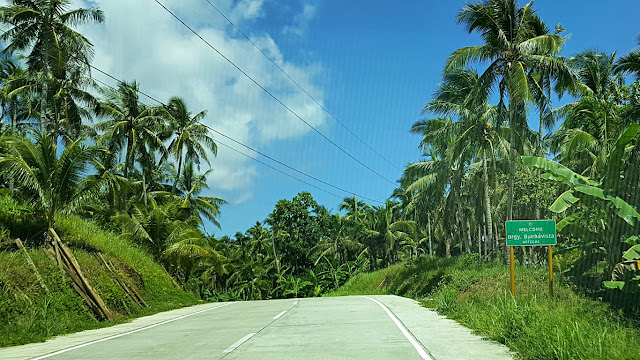 My first time to this town in the northern coastal tip of the province of Eastern Samar. And I was more than happy to note (as I did not expect this) that the road is good new concrete all the way from Oras!
Also happy to note that, far-flung and remote as this town is, newly built infrastructure abound.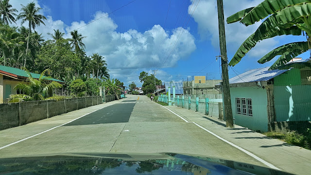 School gates, school fences, barangay halls, multi-purpose covered courts, etc. are either newly built or newly repaired. I think these all came about after the big typhoons (yes plural, as there were more that came after Yolanda), where help really poured in. And/Or because it is "election year". Alams na!
Just two kilometers from Buena Vista, we reached this big barrio called Brgy. Carapdapan..,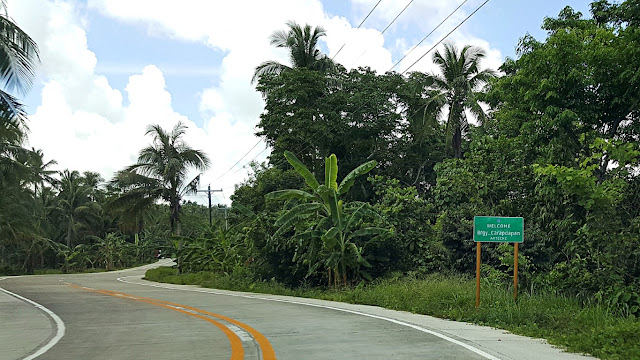 I noticed many parts of this highway sport this kind of sashaying balu-baluktot style. Ano ito, pa-uso?
Hey look here, this certainly looks like a town's plaza, right? That's just Barangay Carapdapan..,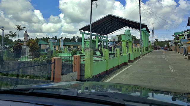 Oh, over at that corner where the highway bends to the left, there is a kilometer marker (K0956) that is probably the only one of its kind in the country! The markings aren't etched in the usual "back-to-back" on the concrete post but on adjacent sides. To ensure (I guess) that it's visible and useful to travelers!
My bad, I wasn't able to take a pic of that kilometer marker as I was busy looking at the covered court.
Anyway, I saw some signage, there is a barangay in this town that is named "Garden". O ha?! Don't you think that is a nice name for a barangay? Kesa naman sa "Barangay Baliw" or "Barangay Campokpok", "Barangay C" or "Barangay 109-A", which are either ludicrously uncreative or scandalously outrageous!
But, the driver seemed very eager to ruin my appreciation of "Garden" when he excitedly announced to me that Arteche also has barangays that are named "Bigo" and "Casisidman"! Nge! I am okay pa sana with "Bigo", but "Casisidman"? It means 'the darkness'.., more associated with the evilish realm! Hiyay!
Good we did not have to pass by them as they are far barangays from the highway hahaha!
After a bridge, I knew we were entering the center of town when I saw big flower pots on the sides!
See? After the bend, we already saw the welcome signage! I said again., Hello Arteche!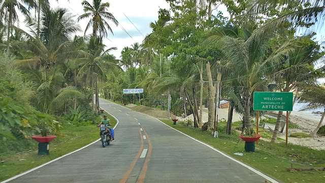
Seeing this newly opened gas station, I heard my driver exhale a breath of relief hehe! Pretending I knew the place, I told him "di ba Petron tayo, meron sa unahan" (I just actually saw a sign post as we entered town (two photos above)! See? Even drivers aren't familiar with this remote town!
If I may recall those yesteryears when I was young and had no sense hehe, San Policarpo and Arteche were considered to be very hard to reach, remote (even if coastal) towns. The only way to reach them was via small outrigger boats from Oras, that must brave the big Pacific Ocean waves. Now, "look at"!
That was as late as already in this century na! But now, you can reach them in any kind of land vehicle!
Anyway, just about a hundred meters forward.., here is the Petron Gas Station. Yeah, ang galing ko! Yep over there at right, beside the kilometer marker. Which by the way, is KM960 and is also the town's K-Zero (K0) marker. Why? Ah, let's research on that, since the munisipyo is about 500 meters away pa.
Look here, the St. Raymund Nonnatus Parish Church of Arteche, Eastern Samar..,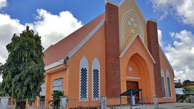 Similar in color to that of San Policarpo, and similarly facing the high roof of a multipurpose court! So, it is hard (actually impossible) to take a full frontal picture of the building's façade. But this was open!
Yep, I entered at an open side door, because look, the front (main) door was securely closed. Riput!
I like the brightness and airiness inside. I also like the simple uncluttered altar.., Driver and I had a debate if there's going to be a ceiling of sorts or that's already it! I said there will be!
On another side of the plaza.., the Arteche Municipal Hall. Wow 'no?! Wide front space. Beautiful!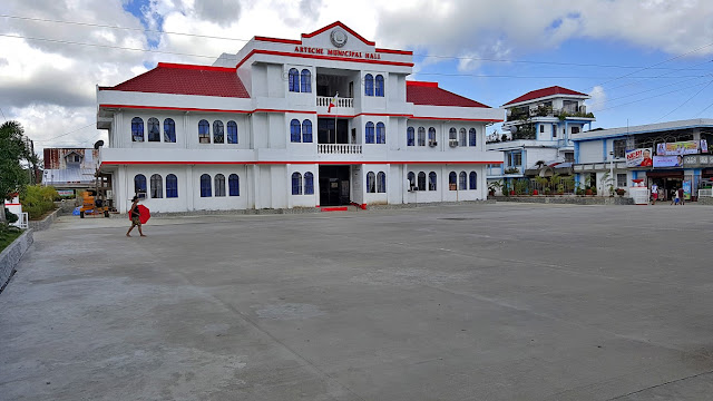 We tried circling around to the back of the building as it looked too thin from this vantage. However..,
That name written on this corner signage decidedly added another destination to my itinerary, pronto!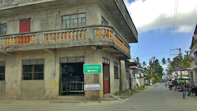 We went to look at the back of Arteche Municipal Hall, and I saw they were like extending the building backwards, but my focus was now on going to Lapinig (while the driver focused on discouraging me)!
We asked a man on the side of the road as to how far is Lapinig from Arteche. The "very informatively apt" reply was something like "ah it's very near it won't even take you half an hour"! Tinatanong ko ang "how far" and he explained "how long will it take"! It was encouraging enough, but I was not contented!
After a few meters I asked the driver to stop by a woman so I can ask again (she looked like a teacher eh). Her reply to the same question was also "harani la it", and she further explained that Brgy. Imelda, the junction to Jipapad is about 20kms from where we were, and finished it with "Lapinig na it". GORA!
Ahh I was ecstatic (but not my driver hahaha)! Imagine that.., I was on my way to the very boundary of Eastern and Northern Samar provinces! And might even see "Japan" - it's a local moniker for Jipapad!
I was like "go go go ra" in my mind! I knew I must have been grinning! To add to the fun, I saw this..,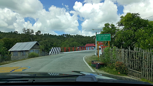 The sign says "Boblaran Bridge". And look at the golden thing at lower left of the pic. Very descriptive! They have a relation! Boblaran is an area where you place things to be sun-dried. That comes from the root word "bulad" meaning to sun-dry. Meaning, the bridge is a palay (rice), coconut (copra) etc. drying area to local residents! That's its primary use to them, since they are farmers/fishermen, not travelers!
Interesting how a trivial bridge-name can reveal the way of life (isn't that culture?) of a barrio!
Onwards, the driver kept looking at his watch. At 10:30AM, I took a pic of this kilometer marker. My intention was to check how many kilometer more did we need to travel to reach Lapinig. Sadly, it is a blank hahaha! But seeing that this is KM962, and I recalled that Petron (above) was/is KM960.., then we were still far, as this was only 2kms out of Arteche town center, this might even still be poblacion!
Then I saw that we were entering Barangay Tangbo OF Arteche. Therefore we were still far (hehe)!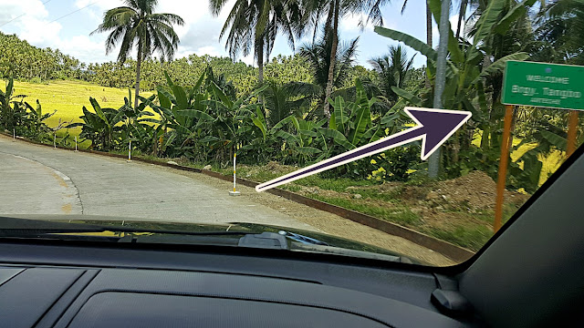 Aha! I know what Tangbo means, it is "Tambo" in Tagalog. So what is it? Ah um... a kind of tall grass, a reed that grows in the marshes or wetlands like near or with mangroves! They are dried and made into brooms! "Walis tambo"! Oh ha? Project ko yan nung elementary ako! Maybe there are lots of that here.
And I saw another of those sashaying swaying kind of road. When does it really need to be so? Okay, our road veers right and that one that goes left is a road to Brgy. Bato. Still, why is it curvilinear?
And as if to stress my point, after the above 'curvaceous' road, this immediately follows.., I don't know, but I'm curious to know about technicalities. Is it too late for me to become an engineer?
Yes it's too late, remain a travel blogger na lang.., and we entered Brgy. Catumsan, STILL in Arteche!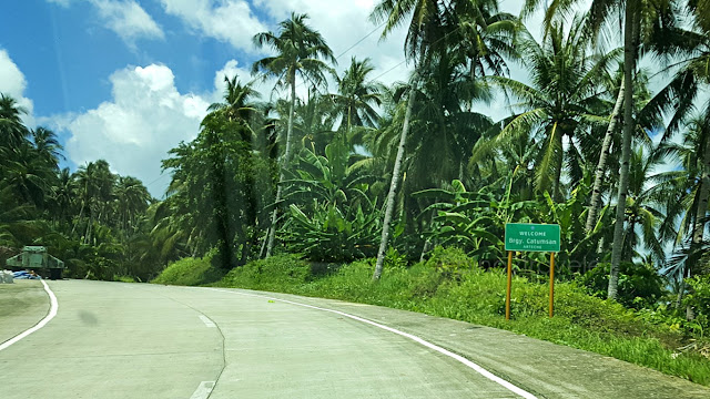 But it was just 10:39AM, so I jokingly told my driver "this won't take a whole month, promise" hehehe!
And oh, I also "instinctively" know something about that name. It comes from the root word "tumos"! Yes gad "nga tunos ka" was a favorite expression of Memo Mayo, my 'yayo' when I was little! So I had to know what "tumos" means. That's waray for a coconut seedling. So there are a lot of "tumos" here?
A few meters from the above "welcome", we encountered this intersection that I got curious about... But there was no signage and no people to ask. We moved on, but stopped at the first human I saw. I asked where that road leads to. And just as I thought, it goes to other barrios of Arteche, all the way to "Japan" (Jipapad) though not yet passable at the moment due to road concreting. Good information!
Finally, at 11:38AM we reached the northern end of Arteche - which is also the end of Eastern Samar!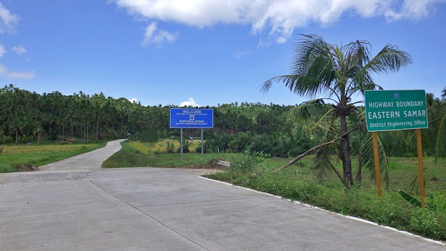 There is no telltale sign of this boundary other than there is a box culvert because it is tiny little creek. But the engineering districts of both provinces planted those signages each announcing their realms.
I would wish they erect something more memorable, historic or catchy ek ek for the tourists/visitors!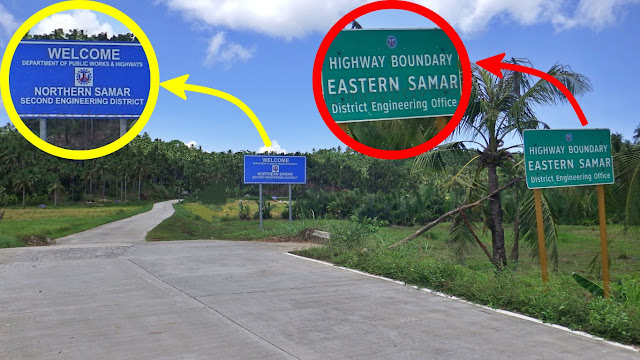 If you read those two boards, you will naturally think "so what" "eh ano ngayon"! Are they not somehow announcing to the public so that we know who to blame or ridicule when something is wrong with the road on either side? What do I care which province, eh are they not the same DPWH of this country?
If I may suggest, they should put something "makalilisang" at this boundary like "PAGHIROT, YOU ARE NOW LEAVING THE PROVINCE OF ATARA"! Ganun! Something a traveler will never easily forget hehe!
Hahaha okay, let's end it here for the meantime. But I am not done with this joyride yet!
I went to see Lapinig, remember? That's next!

Also happy to note that, far-flung and remote as this town is, newly built infrastructure abound.

Just two kilometers from Buena Vista, we reached this big barrio called Brgy. Carapdapan..,

Hey look here, this certainly looks like a town's plaza, right? That's just Barangay Carapdapan..,

My bad, I wasn't able to take a pic of that kilometer marker as I was busy looking at the covered court.
Anyway, I saw some signage, there is a barangay in this town that is named "Garden". O ha?! Don't you think that is a nice name for a barangay? Kesa naman sa "Barangay Baliw" or "Barangay Campokpok", "Barangay C" or "Barangay 109-A", which are either ludicrously uncreative or scandalously outrageous!
But, the driver seemed very eager to ruin my appreciation of "Garden" when he excitedly announced to me that Arteche also has barangays that are named "Bigo" and "Casisidman"! Nge! I am okay pa sana with "Bigo", but "Casisidman"? It means 'the darkness'.., more associated with the evilish realm! Hiyay!
Good we did not have to pass by them as they are far barangays from the highway hahaha!
After a bridge, I knew we were entering the center of town when I saw big flower pots on the sides!

See? After the bend, we already saw the welcome signage! I said again., Hello Arteche!

Seeing this newly opened gas station, I heard my driver exhale a breath of relief hehe!

If I may recall those yesteryears when I was young and had no sense hehe, San Policarpo and Arteche were considered to be very hard to reach, remote (even if coastal) towns. The only way to reach them was via small outrigger boats from Oras, that must brave the big Pacific Ocean waves. Now, "look at"!
That was as late as already in this century na! But now, you can reach them in any kind of land vehicle!
Anyway, just about a hundred meters forward.., here is the Petron Gas Station. Yeah, ang galing ko!

Look here, the St. Raymund Nonnatus Parish Church of Arteche, Eastern Samar..,

Yep, I entered at an open side door, because look, the front (main) door was securely closed. Riput!

I like the brightness and airiness inside. I also like the simple uncluttered altar..,

On another side of the plaza.., the Arteche Municipal Hall. Wow 'no?! Wide front space. Beautiful!

That name written on this corner signage decidedly added another destination to my itinerary, pronto!

We asked a man on the side of the road as to how far is Lapinig from Arteche. The "very informatively apt" reply was something like "ah it's very near it won't even take you half an hour"! Tinatanong ko ang "how far" and he explained "how long will it take"! It was encouraging enough, but I was not contented!
After a few meters I asked the driver to stop by a woman so I can ask again (she looked like a teacher eh). Her reply to the same question was also "harani la it", and she further explained that Brgy. Imelda, the junction to Jipapad is about 20kms from where we were, and finished it with "Lapinig na it". GORA!
Ahh I was ecstatic (but not my driver hahaha)! Imagine that.., I was on my way to the very boundary of Eastern and Northern Samar provinces! And might even see "Japan" - it's a local moniker for Jipapad!
I was like "go go go ra" in my mind! I knew I must have been grinning! To add to the fun, I saw this..,

Interesting how a trivial bridge-name can reveal the way of life (isn't that culture?) of a barrio!
Onwards, the driver kept looking at his watch. At 10:30AM, I took a pic of this kilometer marker.

Then I saw that we were entering Barangay Tangbo OF Arteche. Therefore we were still far (hehe)!

And I saw another of those sashaying swaying kind of road. When does it really need to be so?

And as if to stress my point, after the above 'curvaceous' road, this immediately follows..,

Yes it's too late, remain a travel blogger na lang.., and we entered Brgy. Catumsan, STILL in Arteche!

And oh, I also "instinctively" know something about that name. It comes from the root word "tumos"! Yes gad "nga tunos ka" was a favorite expression of Memo Mayo, my 'yayo' when I was little! So I had to know what "tumos" means. That's waray for a coconut seedling. So there are a lot of "tumos" here?
A few meters from the above "welcome", we encountered this intersection that I got curious about...

Finally, at 11:38AM we reached the northern end of Arteche - which is also the end of Eastern Samar!

I would wish they erect something more memorable, historic or catchy ek ek for the tourists/visitors!

If I may suggest, they should put something "makalilisang" at this boundary like "PAGHIROT, YOU ARE NOW LEAVING THE PROVINCE OF ATARA"! Ganun! Something a traveler will never easily forget hehe!
Hahaha okay, let's end it here for the meantime. But I am not done with this joyride yet!
I went to see Lapinig, remember? That's next!


Comments
Post a Comment