Into San Isidro
On with the joyride! And my next 'destination' was the town of San Isidro, Leyte.
It's only about 15kms to the north of Tabango, passing via the 'relatively new' upland highway. The old coastal road is still there and well in use. We even initially planned to pass that way, since the white sandy beaches of Tabango are in that area (like Buho Beach). And it is not very long a road too, probably just about 20kms. But, I received word that we avoid the route due to on-going road repairs :(
Not that I did not like passing by this upland route. There were interesting scenes too. Like this.., A vegetable plantation - which is not a common sight in this region (Regio 8). Do you agree? I mean, in my travels, I noticed that the Waray-waray's farmland is usually planted to rice (and nothing else), or.., coconuts (and nothing else), or.., nothing at all! Especially smaller patches of land.., unused.., forever!
That's why I felt good having seen that little cash-crop plantation! Look, the 2 manongs are harvesting aubergine from the lower left quadrant of the field! Ano nga "aw virgin" sir, so asked my driver hehehe! So I said "talong, tarong, taron or eggplant" hahaha! By the way, this is "terong" in Malay or Indonesian!
There are only two men. The blue-colored thing at lower-left of the picture is a weighing scale. Yes, that means these farmers (can) sell their produce right then and there, upon harvest. That's 'freshiest'!
Do you notice that differently-colored patch of green back there, where the solo coconut stands? That must be another veggie crop though am not sure what kind. The upper right patch (newly plowed) has nothing planted yet, while the green colored edge at lower-right of the same picture is just grass hehe!
You may be wondering why I am giving such a fuss over that simple farm picture. That is because, in Leyte, Samar and Biliran, there are vast tracts of land that are just left unused for farming vegetables! You will easily see this if you travel around. Especially if you compare to places like the Ilocos region.
Okay anyway, let's proceed..,
Because of Campokpok Bridge, I've watched out for bridge names, lest I see another funny one..,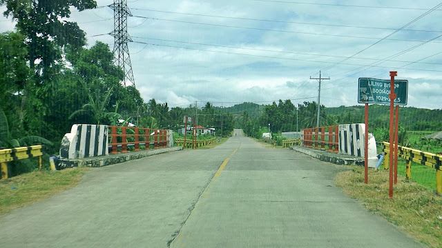 This one is (I think) a normal name so far - Liling Bridge. Y'know, siya o ikaw.., may ti-Liling!
This one is Cabayogan Bridge. Nothing out of this world, right? Though I don't know what is "bayog"!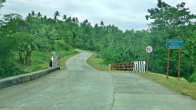 But my forehead creased a little bit at the sight of that pavement after the bridge. I wonder, does/did it really need to 'sway' like that? It not only swerves left and rigt, it also curves up and down! Fun'ny' ride!
Ah, didn't Is ay "upland highway" in the second paragraph above? Here's an example!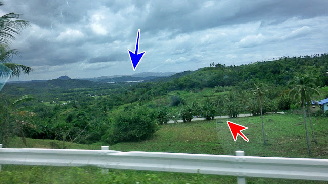 To get a 'feel' of how high this road is, look at the blue arrow, it points to the sea far and down below. And also look at where the red arrow points to. That is where we just came from and still clambering!
After some time, the road starts to wind down. You also start seeing snippets of the sea. Amazing! I imagined it would probably also be fun riding a skateboard on this downhill run. Or a scooter, or any other non-engine vehicle! There are but a few vehicles here anyway! Oops, masuko si barangay baktin!
On second thought, I realized it's not even a good idea frequenting this highway (as of now anyway)..,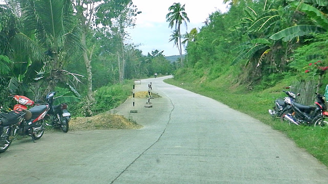 There are a number of roadslips and landslides that dot this stretch, until the highway is at sea-level.
Oist, did you notice? If a road's pavement is falling off a ridge, cliff or hill, they call it a roadslip. But if a hill or mountain is falling unto the road, they call it a landslide! But they mean one thing to me: danger!
I think there must have been something wrong with the construction of this stretch of the highway, as we can see the pavement is fairly new. Yet, many parts of it are falling off. Hm, howsoever we look at this, may katiwalian man o wala.., may kababalaghan man o wala.., meron hindi tama ang pag-gawa!
Because down at ground/sea level portions.., this same road is admirably good naman.., See that? This highway looks nice. Aside from being clean and uncluttered, it seems durable naman!
Oh here's another bridge! Kinareer na ang tulay! This one is named "Tabing Bridge"..,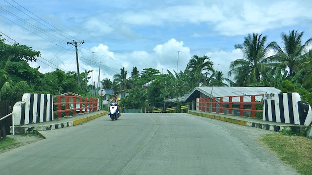 But somewhere along, I saw another bridge named "Tabang", aside from "Tabango Bridge"!
And hey, there were also a scattering of beautiful houses like this, even out in the farm fields.., These were already part of, but still kilometers way outside of the central district/area of San Isidro.
Ah this one got me into another fit of grinning and chuckling because, it is named "Imbornal Bridge"! Hahaha, ano ba talaga, imburnal o tulay? That is the crazy hilarity that driver and I debated at length!
If you notice, the bridge name is spelled in the Spanish version [Imbornal with an "O"]. Meron touch of 'alta sociedad' or 'conyo', at least, di ba hehe! In Tagalog, Bisaya, Waray or other Philippine languages, that is usually spelled Imburnal (with the U). But an imbornal or imburnal is never a bridge, so how can it be? A basta, walang basagan ng trip! They want to call it Imbornal Bridge, so be it! Walang kokontra!
At least, this Imbornal.., bridge I mean, does not at all look and/or smell like an imburnal!
Hey, I saw more big wooden old houses still along the way..,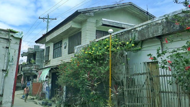
 That second one is even already dilapidating! That's the problem with wood. And because as humans, this was our 'technology' of yesteryears, we have caused deforestation. If only science can solve this.
Anyway, I next saw this big wide clearing on the left side of the road. I thought 'another quarry'..,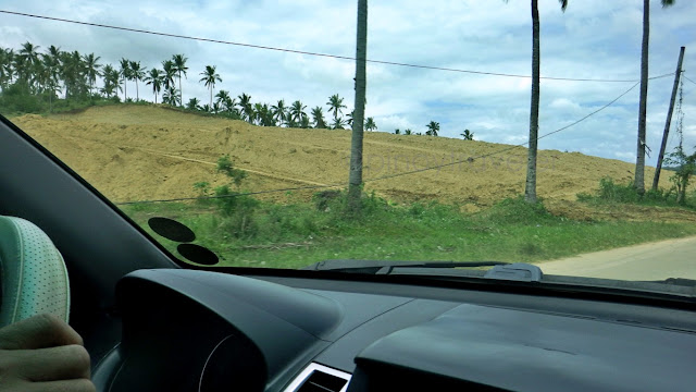 But on one corner (I was unable to capture with my phone camera), there was a sign that said "on this site will rise 600 houses" by NHA. Yep, the National Housing Authority. Da! That is one big population!
We laughed again, because our crazy creative minds started thinking forward.., like how would people refer to their residences directionally in the future? "Ako si Kiko, taga-housing, duol sa imbornal"! Nge!
Anyway again, final approach, this was KM1018, exactly 1 kilometer to center of town.., That road at left (that merges with the national highway) comes from their San Isidro Port. Oops teka, this could get confusing.., I mean the San Isidro (Leyte) Port. Because there is a San Isidro (Northern Samar) Port. Incidentally, both San Isidros are on the north-western parts of their respective islands!
These are the 4th and 5th towns that we mentioned here.
But let's see more of San Isidro, Leyte in my next story!
It's only about 15kms to the north of Tabango, passing via the 'relatively new' upland highway.

Not that I did not like passing by this upland route. There were interesting scenes too. Like this..,

That's why I felt good having seen that little cash-crop plantation! Look, the 2 manongs are harvesting aubergine from the lower left quadrant of the field! Ano nga "aw virgin" sir, so asked my driver hehehe! So I said "talong, tarong, taron or eggplant" hahaha! By the way, this is "terong" in Malay or Indonesian!
There are only two men. The blue-colored thing at lower-left of the picture is a weighing scale. Yes, that means these farmers (can) sell their produce right then and there, upon harvest. That's 'freshiest'!
Do you notice that differently-colored patch of green back there, where the solo coconut stands? That must be another veggie crop though am not sure what kind. The upper right patch (newly plowed) has nothing planted yet, while the green colored edge at lower-right of the same picture is just grass hehe!
You may be wondering why I am giving such a fuss over that simple farm picture. That is because, in Leyte, Samar and Biliran, there are vast tracts of land that are just left unused for farming vegetables! You will easily see this if you travel around. Especially if you compare to places like the Ilocos region.
Okay anyway, let's proceed..,
Because of Campokpok Bridge, I've watched out for bridge names, lest I see another funny one..,

This one is Cabayogan Bridge. Nothing out of this world, right? Though I don't know what is "bayog"!

Ah, didn't Is ay "upland highway" in the second paragraph above? Here's an example!

After some time, the road starts to wind down. You also start seeing snippets of the sea. Amazing!

On second thought, I realized it's not even a good idea frequenting this highway (as of now anyway)..,

Oist, did you notice? If a road's pavement is falling off a ridge, cliff or hill, they call it a roadslip. But if a hill or mountain is falling unto the road, they call it a landslide! But they mean one thing to me: danger!
I think there must have been something wrong with the construction of this stretch of the highway, as we can see the pavement is fairly new. Yet, many parts of it are falling off. Hm, howsoever we look at this, may katiwalian man o wala.., may kababalaghan man o wala.., meron hindi tama ang pag-gawa!
Because down at ground/sea level portions.., this same road is admirably good naman..,

Oh here's another bridge! Kinareer na ang tulay! This one is named "Tabing Bridge"..,

And hey, there were also a scattering of beautiful houses like this, even out in the farm fields..,

Ah this one got me into another fit of grinning and chuckling because, it is named "Imbornal Bridge"!

If you notice, the bridge name is spelled in the Spanish version [Imbornal with an "O"]. Meron touch of 'alta sociedad' or 'conyo', at least, di ba hehe! In Tagalog, Bisaya, Waray or other Philippine languages, that is usually spelled Imburnal (with the U). But an imbornal or imburnal is never a bridge, so how can it be? A basta, walang basagan ng trip! They want to call it Imbornal Bridge, so be it! Walang kokontra!
At least, this Imbornal.., bridge I mean, does not at all look and/or smell like an imburnal!
Hey, I saw more big wooden old houses still along the way..,


Anyway, I next saw this big wide clearing on the left side of the road. I thought 'another quarry'..,

We laughed again, because our crazy creative minds started thinking forward.., like how would people refer to their residences directionally in the future? "Ako si Kiko, taga-housing, duol sa imbornal"! Nge!
Anyway again, final approach, this was KM1018, exactly 1 kilometer to center of town..,

These are the 4th and 5th towns that we mentioned here.
But let's see more of San Isidro, Leyte in my next story!


Comments
Post a Comment