Deciphering The Kilometer Marker
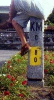 I thought you said “km 0” is the Rizal monument in Manila (Luneta). Then why is that ass sitting at a “km 0” that does not look to be anywhere near Luneta?
Now now, calm down my dear cayvan (that means friend in Ivatan). Especially in this country, there are always exceptions to every rule!
The topic we had in the previous entry is if and when you can travel by land from Luneta (e.g., to Pili, Camarines Sur).
That 'ass', is sitting at the kilometer marker in front of the Batanes Provincial Capitol which, as we know, is an island way up north, right? That is one such exception.
When the province, city or town is on a separate island, what becomes “kilometer zero” is usually the highest seat of government on the island. And in this particular example, it’s the provincial capitol of Batanes located in Basco.
That is why you also see “B” and another “0” below the “KM” and “0” because he is sitting at zero kilometers away from Basco, Batanes. He is in the very heart of it, to be exact!
This is what I meant with “localized kilometer zeros” in the last paragraph of the previous story.

And oops, didn’t we say only the first letter is used? Why is it an SV now, that’s two letters?! Ah, another exception! SV means San Vicente for people to easily distinguish it from the next locality which is named Savidug that also starts with a letter “S”! Capice?!
Oops again, didn’t we say “km 0” markers are supposed to be at the seat of government? Why does this look like it is a residential house? Well, another exception hehe. It might interest you to know though, that this house is right next to the church and across it is a school that seems to have been just about where their original seat of government may have been in the past.
Confusing or aliw? Ah, live with it hehe!
Let’s complicate and/or politicize matters, shall we? Those two words are synonyms anyway, right?

That marker is right in front of the giant flagpole fronting the beautiful Cebu Provincial Capitol building. The “M” is Mandaue City and yes, that is 7 kilometers away from this point. What happened to Cebu City that is probably just about 2 kms away? Why is it not the reference? Isn't it the capital of Cebu Province?
Ah, its either the city mayor does not want his city mentioned by the province or the governor does not want to mention that city because it does not belong. Does not belong?!
Well, your head will spin like a trumpo if you keep minding the complexities of HUCs and/or “independent” and/or “component” cities. Especially if mayors are at odds with governors. As for our topic, “exception” should be a better word for it.
Mind you, kilometers (in 100% radii) around this place is Cebu City big and real. AND, this is probably the kilometer marker that has seen so many inscription facelifts in its time. You can try collecting old photos of that capitol and you will notice the various changes this lowly marker has gone through!
Entawon! Mao na na diha Tomas, Gwendolyn. Samoka ninyo oi!
 Hello, where is this “km 0” marker that is 1,701 kilometers away? Is there even an island in this archipelago that is a thousand kilometers long?
Well relaaaax… “exceptions” y’know!
Actually this is somewhere 'near across' ("malapit sa tapat" - tama ba English ko?) the church in Ozamis City, that’s why you see a letter “O” and a zero “0”. And yes, the city is just a few kilometers from its provincial capital which is Oroquieta.
But that 1,701 kilometers refers to Luneta.
Hep hep, hold your horses and tamaraws! The advent of this thing called Maharlika Highway a.k.a Pan Philippine Highway caused these kilometer markers to “recalibrate”. Why? Because nowadays, you can drive straight from Manila to these places as far as the ends of mainland Mindanao.
That is why. So, if you are in Ozamis City, you are about 1,701 kilometers from Rizal Park in Manila!
But why are other islands’ markers not relabeled when you can also drive to them from Manila like Panay, Negros, Cebu, Bohol, Masbate, etc? My answer? “Beats me” hehe! It could be coming.
If they don’t do it, it won't hurt anyone, right?! If they do though, gosh there must be multitudes of issues the DPWH folks will have to tackle.
Take the case of Tagbilaran. If you attempt to measure it in terms of kilometers from Luneta, how do you count after crossing from Southern Leyte to Ubay? Rightwards via Talibon, Getafe, Buenavista etc., or leftwards via Alicia, Guindulman, Jagna, etc., or the central highway via San Miguel, Carmen, Bilar, etc?
Then Tagbilaran City will have a dizzying mix of kilometer markers! Gosh, we better leave it as it is now hehe! Makabuang!
Finally, why are these posts sometimes on the left and sometimes on the right side of the road? Oh, someone from the DPWH told me that all are supposed to be on the right side of the road if you are driving away from “km 0“.
So if you see that the markers are on your left, then you must be going back to it. He says he is not sure about this, but some locally installed markers may not follow that norm, or some markers may have been uprooted and transplanted for aesthetic or political purposes. Ganun!
Anyway, lets stress that point… if the marker is on the right side of the road, km 0 is behind you, therefore if its on the left, you are going towards km 0! Now that helps me a lot!
Alrightie, let’s finish this off with a few more examples:


--- a very interesting read for that 'lowly' marker - that helped (or confused) a lot motorists... this is very informative... thanks again...
ReplyDeletevery interesting!
ReplyDeletei also wonder those numbers marked on bridges. i think the numbers also indicate distance from the prov capitol and weight limit of the bridge, not sure..
thanks boss! you are the best travel guru... pwede rin travel guro hehe
ReplyDeleteLots of information and very well explained...I felt dizzy while trying to absorb this zero markers explanation. You are the best...thank you
ReplyDeleteHello po para po sa Assignment po namin ano pong location nung isang example na may circle plsss po
ReplyDelete