Posts

Showing posts with the label Capoocan

Sights & Scenes: Palompon to Ormoc to Tacloban

Image
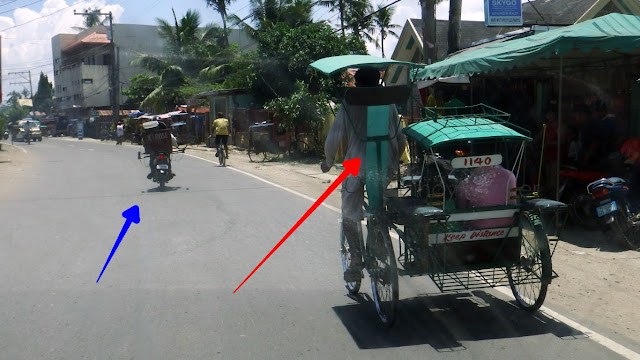
I was returning to Tacloban from Palompon after a visit of Kalanggaman Island, and here are some interesting views that invited the curiosity of my camera along the way... First up, while wading our way out of Palompon... Red arrow points to an uncommon (rare actually) pedicab with a driver's backrest! I have seen many pedicabs since yesterday, but, only this one sports that 'luxurious' backrest. Why and when needed? I can't imagine! Driver needs to rest while on a "long drive"?! Blue arrow points to a motorbike loaded with a big fish container. Well, at least this one is a common sight in this country, but just the same, it amazes me that such a wobbly unstable mode of transport can carry that heavy a load. What if it topples? Fish spread! Here's another one. Ah, blue arrow is the same dude as above... But red arrow points to another rider carrying a lighter load (I guess). However, those are TWO styropore boxes, one on top of the other, AND not at

NOT Because of Yolanda

Image
Kids in these pictures are begging for whatever coin drivers or passengers might toss to them. This is at the mountainous barrios of Capoocan, just after Kanga. I agree they need help. BUT not necessarily because of Yolanda. They have been doing this for years. I have pics and vids from previous travels about this very same ‘act’. Their story goes something like this… That stretch of the highway (rather long) have been seeing re-construction of its pavement. And as usual for government entities, said construction does not come in one pass, they do it segment by segment – so there is perennial construction activity in this area. When a portion is upgraded, only one lane can be used by motorists in these steeply inclined, mostly sharp-winding roads – where people are needed to guide motorists when to proceed or wait. In the past, they would even use colored flags (green and red) to do this. I started shooting every time I pass when there were times mothers did the “guiding”. Then came th

Deciphering The Kilometer Marker

Image
I thought you said “km 0” is the Rizal monument in Manila (Luneta). Then why is that ass sitting at a “km 0” that does not look to be anywhere near Luneta? Now now, calm down my dear cayvan (that means friend in Ivatan). Especially in this country, there are always exceptions to every rule! The topic we had in the previous entry is if and when you can travel by land from Luneta (e.g., to Pili, Camarines Sur). That 'ass', is sitting at the kilometer marker in front of the Batanes Provincial Capitol which, as we know, is an island way up north, right? That is one such exception. When the province, city or town is on a separate island, what becomes “kilometer zero” is usually the highest seat of government on the island. And in this particular example, it’s the provincial capitol of Batanes located in Basco. That is why you also see “B” and another “0” below the “KM” and “0” because he is sitting at zero kilometers away from Basco, Batanes. He is in the very heart